Skip to content

Bargarh district

ବରଗଡ଼ ଜିଲ୍ଲା

Bargarh is a western Odisha district known for Hirakud-irrigated paddy, Sambalpuri handloom, Dhanu Jatra, Nrusinghanath temple and Debrigarh sanctuary.

Headquarters
Bargarh
Population (2011)
1,481,255
Area
5,837 sq km
Villages
1,215
Literacy (2011)
74.6%
Towns (2011)
8

Bargarh (ବରଗଡ଼) is a district in western Odisha, bordering Chhattisgarh. Its headquarters is the town of Bargarh, on the Jira river. Odisha Tourism now uses the Odia-based spelling Baragada, following the state's 2026 revision of English place names.

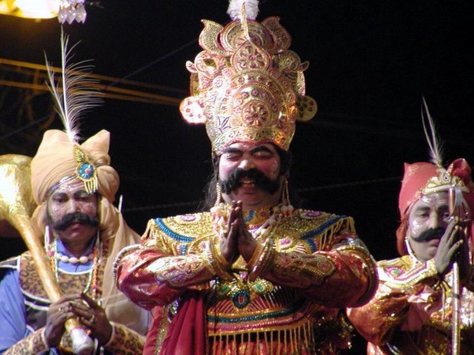
The district is known for its farms, its looms and its theatre. Water from the Hirakud dam irrigates the northern plains, which grow large paddy harvests and earn the district the popular title of Odisha's "rice bowl". Bargarh is a major centre of Sambalpuri handloom, home to the large Sambalpuri Bastralaya cooperative. Every winter the whole town becomes the stage for Dhanu Jatra, which is often described as the world's largest open-air theatre.

Bargarh was carved out of Sambalpur district on 1 April 1993. It has two sub-divisions, Bargarh and Padampur, with 12 tahasils and 12 blocks.

At the 2011 Census the district had 1,481,255 people on 5,837 sq km, a density of about 254 per sq km. The literacy rate was 74.62%, and the district had a high sex ratio of 977 females per 1,000 males.

People of Bargarh district

Census 2011 counted 14,81,255 people in 3,70,308 households in Bargarh district. 10.1% lived in towns, and the literacy rate (age 7 and over) was 74.6%. The census recognised 8 towns in the district.

Population
14,81,255
7,49,161 male · 7,32,094 female
Households
3,70,308
about 4.0 people each
Literacy (age 7+)
74.6%
men 83.7% · women 65.4%
Females per 1,000 males
977
Girls per 1,000 boys (0–6)
957
People per km²
254
  • Rural13,31,145 (89.9%)
  • Urban1,50,110 (10.1%)
Scheduled Castes
2,98,780 (20.2%)
Scheduled Tribes
2,81,135 (19.0%)

What the 7,62,092 workers did

  • Cultivators1,73,496 (22.8%)
  • Agricultural labourers1,52,438 (20.0%)
  • Household industry34,886 (4.6%)
  • Other work1,13,570 (14.9%)
  • Marginal workers2,87,702 (37.8%)

Marginal workers worked less than six months of the year.

Source: Census of India 2011, Primary Census Abstract (district, sub-district and town level). Figures are from 2011, the most recent census with published district, town and village figures.

Facilities in the villages of Bargarh

How many of the 1,179 inhabited villages of this district had each facility within the village itself, from the Census 2011 Village Directory. Together the 1,206 villages cover 4,587 km², 74% of it sown with crops and 5% forest.

Education

  • Primary school1,178 of 1,179
  • Middle school833 of 1,179
  • Secondary school277 of 1,179
  • Senior secondary school295 of 1,179
  • Degree college65 of 1,179

Health

  • Primary health centre5 of 1,179
  • Health sub-centre185 of 1,179
  • Anganwadi centre1,110 of 1,179

Water & power

  • Treated tap water0 of 1,179
  • Hand pump1,143 of 1,179
  • Electricity for homes1,126 of 1,179

Roads & transport

  • All-weather road801 of 1,179
  • Public bus98 of 1,179
  • Mobile phone coverage1,130 of 1,179

Services

  • Post office or sub post office207 of 1,179
  • Commercial bank8 of 1,179
  • Ration (PDS) shop328 of 1,179
  • Weekly haat155 of 1,179
Primary schools
1,591
Middle schools
930
Secondary schools
613
Degree colleges
66
Primary health centres
9
Health sub-centres
185

Main crops named by villages: Paddy (1,146), Pulses (605), Ground Nuts (366), Badam (166), Vegetables (107), Groundnut (83), Sugarcane (69), Mung (51). Handicrafts: Weaving Products (78), Tailoring (16), Bamboo Products (15), Weaving (14), Broomstick (14), Bamboo Materials (14), Iron Products (9), Earthern Pots (7).

Source: Census of India 2011, District Census Handbook: Village and Town Directory (Odisha). The facilities were recorded for the 2011 census (reference year 2009 for most items); many places have changed since. Facilities in towns are not included.

Towns of Bargarh

3 statutory towns (municipal corporation, municipality, notified area council or industrial township) and 5 census towns — places the census counted as urban but which are governed by gram panchayats.

TownTypePopulationLiteracyWards
BargarhMunicipality80,62588.4%19
BarapaliNotified Area Council20,85083.7%11
PadmapurNotified Area Council17,62583.3%11
BijepurCensus town6,92285.4%–
SohelaCensus town6,91783.5%–
KhaliapaliCensus town6,86582.8%–
BardolCensus town5,44178.8%–
BhatliCensus town4,86578.2%–

Population of the town itself; for towns with outgrowths, the town page also gives the figure including them. Ward counts are the census wards of 2011.

Census sub-districts: town and country

Sub-districtPopulationRuralUrbanLiteracy
Paikamal91,91691,916066.0%
Jharbandha1,03,6761,03,676067.6%
Padmapur81,25963,63417,62573.5%
BurdenP.S.33,25933,259068.0%
Gaisilet77,44377,443068.2%
Melchhamunda70,23970,239075.6%
Sohela1,04,56697,6496,91776.0%
Bijepur1,07,3741,00,4526,92274.8%
Barapali1,28,2711,07,42120,85076.5%
Bheden1,27,4001,27,400076.8%
Bargarh1,64,13171,20092,93182.1%
Bargarh Sadar78,38978,389073.7%
Bhatli90,32185,4564,86575.7%
Ambabhona65,71565,715077.5%
Attabira1,57,2961,57,296075.2%

Odisha's census sub-districts are police-station areas, not revenue tahasils.

History

Bargarh lay in the ancient region of Dakshina Kosala. Wikipedia's district history traces a series of ruling powers here. The Sarabhapuriyas rose to prominence in the 6th century CE, followed by the Somavamshis. A Kalachuri copper plate of about 1131 CE mentions Vagharakotta, possibly an early name of Bargarh. The Eastern Gangas drove out the Kalachuris around 1211.

From the late 16th century the area was ruled by the Chauhan kings of Sambalpur. According to Wikipedia, the Chauhan king Balaram Dev made Bargarh a fortified headquarters near the Jira river. Wikipedia also records an older name, Bahgar Kota, which Balaram Dev changed to Bargarh.

The Marathas took the Sambalpur kingdom in 1800. After the Third Anglo-Maratha War, Sambalpur became British territory in 1817, and it was annexed under the Doctrine of Lapse in 1849. During the rebellion of 1857 and its long aftermath, Veer Surendra Sai and his allies fought the British across this region. The area took part in the Odia language movement of the 1890s; see history of Sambalpur.

After independence the area remained part of Sambalpur district until Bargarh district was formed in 1993.

Places to visit

Nrusinghanath temple

At the foot of the Gandhamardan hills near Paikmal, about 35 km west of Padampur and 110 km from Bargarh town, stands a temple to Narasimha built by King Baijal Singh Dev of Patna State in the early 15th century. The temple is about 45 feet tall. A big fair is held on Nrusimha Chaturdashi in Vaishakha (around May). Odisha Tourism describes a hilltop trekking route of about 16 km over the Gandhamardan hills from Nrusinghanath to the Harishankar temple on the southern slope, in Balangir district.

Debrigarh Wildlife Sanctuary

Debrigarh's hills and forests run down to the Hirakud reservoir, which draws migratory waterfowl in winter. Odisha Tourism lists leopards, elephants, gaur, deer and wild boar. It recommends visiting from October to March and offers jeep safaris, trails and boat rides. The sanctuary is about 25 km from Hirakud Dam and about 40 km from the Samaleswari temple in Sambalpur, according to Odisha Tourism; see the Hirakud Dam travel guide.

Bargarh town during Dhanu Jatra

During Dhanu Jatra, the streets of Bargarh become Mathura and Ambapali village across the Jira becomes Gopapura. The actor playing Kansa holds court and issues mock orders. Kalinga TV reported about 22 stages within roughly 7 km of the town for the 2025–26 edition.

Barpali

Barpali, a tahasil town in the south of the district, is the birthplace of the poet Gangadhar Meher. It is also known for its own style of Sambalpuri saree.

How to reach

  • By air: The nearest airport is Veer Surendra Sai Airport at Jharsuguda. Biju Patnaik International Airport, Bhubaneswar, has the widest choice of flights.
  • By rail: Bargarh Road station, about 4 km from the town, is on the Jharsuguda–Titlagarh line of the East Coast Railway, with trains to Bhubaneswar, Raipur, Visakhapatnam and Kolkata. Sambalpur is the nearest major junction.
  • By road: Bargarh lies on National Highway 53 (the Kolkata–Mumbai corridor), and National Highway 26 begins here and runs south.

From the coast, most travellers come via Sambalpur. See how to reach Odisha.

Temples (1)

  • Nrusinghanath Temple

Photos and map links in the temple directory. Today's tithi, sunrise and Rahu Kala here.

Railway stations

4 stations and 0 halts inside the district, as mapped on OpenStreetMap; some on new lines may not yet have regular trains.

Culture and festivals

Bargarh belongs to the Sambalpuri-speaking region of western Odisha. Wikipedia's analysis of the 2011 Census reports that about 76% of residents name Sambalpuri as their mother tongue, followed by Odia.

The biggest festival is Dhanu Jatra. It runs for about 11 days in the month of Pausha and ends on Pausha Purnima. Sources date its beginning to 1947 or early 1948. Nuakhai, the new-rice festival held in August or September, is the most important family festival of the region. Sitala Sasthi celebrations have spread from Sambalpur to Bargarh, Padampur and Barpali.

Folk forms such as Dalkhai and other Sambalpuri dances are performed at these festivals to the dhol, nisan and mahuri.

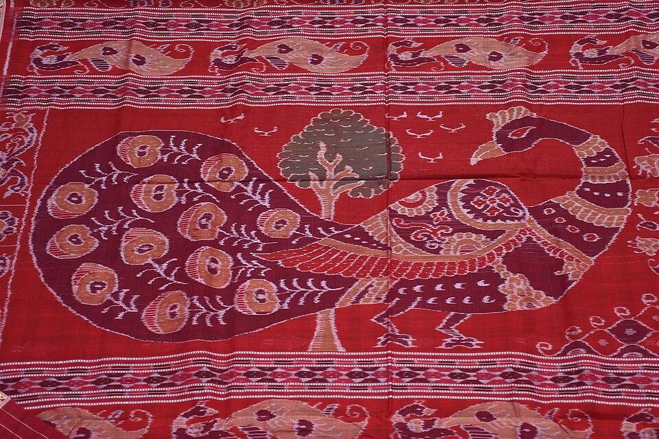
Bargarh is one of the main weaving districts of the Sambalpuri saree, whose bandha (ikat) yarn is tie-dyed before weaving. "Sambalpuri Bandha Saree and Fabrics" is a registered Geographical Indication. The Sambalpuri Bastralaya at Bargarh, founded in 1954, describes itself as one of the country's largest primary weavers' cooperatives. It reports more than 5,600 weavers, 90 affiliated primary societies, and about a quarter of Odisha's cooperative handloom production.

Food

Bargarh shares the cuisine of western Odisha. Regional food writing lists chaula bara, a crisp fried rice-batter snack sold in Bargarh, Barpali and nearby towns. It also describes ambil (a sour vegetable soup), and bamboo-shoot dishes such as kardi (fresh shoots) and hendua (dried or fermented shoots; descriptions vary). Pakhala (fermented rice) is a hot-weather staple across Odisha; see pakhala bhata.

Geography and climate

Bargarh is mainly an open plain broken by small hill ranges. It borders the Chhattisgarh districts of Mahasamund and Raigarh to the north-west, Jharsuguda to the north, Sambalpur to the east, Subarnapur and Balangir to the south, and Nuapada to the west.

The north of the district is watered by canals from the Hirakud reservoir on the Mahanadi. The Jira river flows past Bargarh town. In the south-west rise the Gandhamardan hills, shared with Balangir district, whose highest point reaches about 1,060 m. The Nrusinghanath shrine stands on their northern slope. In Hindu tradition these are the hills from which Hanuman carried healing herbs for Lakshmana in the Ramayana. The Botanical Survey of India has documented about 220 plant species of medicinal value here, and local communities have long campaigned to protect the hills from bauxite mining.

The Debrigarh Wildlife Sanctuary, about 347 sq km of dry deciduous forest, lies on the shore of the Hirakud reservoir. The reservoir bounds it on the east and north.

FeatureDetail
LandformOpen plain with small hill ranges; Gandhamardan hills in the south-west
Rivers and waterMahanadi and Hirakud reservoir canals; Jira river at Bargarh town
Protected areaDebrigarh Wildlife Sanctuary, about 347 sq km
RainfallAbout 1,500 mm a year, mostly in the monsoon
ClimateHot summers, a June to September monsoon and cool, dry winters

Summers are very hot, as in much of western Odisha. Most rain falls in the south-west monsoon, and winters are cool and dry.

Economy

Agriculture is the backbone of the economy. The Hirakud Dam, which Prime Minister Jawaharlal Nehru inaugurated on 13 January 1957 in neighbouring Sambalpur district, transformed farming here by feeding a network of irrigation canals. Wikipedia notes that all-season irrigation from Hirakud makes the northern half of the district rich in agriculture, mostly paddy, and Bargarh town has many rice mills. Its article on the town puts the district's annual rice output at about 600,000 tonnes. Cement and sugar mills also operate in the district. Handloom weaving, organised largely through cooperatives such as the Sambalpuri Bastralaya, is the other major source of income.

Climate of Bargarh

In Bargarh district (at 21.33°N, 83.62°E), the hottest month is May (average highs of 41°C) and the coolest nights come in Jan (15°C). About 1530 mm of rain falls in a year, most of it in the monsoon; Jul is the wettest month.

JanFebMarAprMayJunJulAugSepOctNovDec
Average high (°C)283136404136313031313027
Average low (°C)151822262928252525231915
Rainfall (mm)1612141434226424424269721313
Rainy days1112314242318711

Averages for 1995–2024 at that point (177 m above sea level), from the Open-Meteo historical weather API (ERA5 reanalysis by ECMWF/Copernicus, CC BY 4.0) — modelled values on a ~25 km grid, not station readings from the India Meteorological Department. A rainy day has 2.5 mm or more.

Notable people

  • Gangadhar Meher (1862–1924): Swabhaba Kabi, the poet of nature, author of Tapaswini, born at Barpali into a weaving family.
  • Parbati Giri (1926–1995): freedom fighter jailed during the Quit India Movement and later a social worker, called the "Mother Teresa of Western Odisha", born at Samlaipadar in present-day Bargarh district.
  • Kunja Bihari Meher (1928–2008): master ikat weaver from Bargarh district, awarded the Padma Shri in 1998 for his contribution to Sambalpuri handloom.

Blocks, sub-districts, panchayats & villages

Choose a block, sub-district or town to see its details and its gram panchayats and villages. Open any village for its own page.

Counts below: Local Government Directory, December 2022 snapshot (LGD villages, which can differ from the district administration's revenue-village count).

Blocks
12
Sub-districts
15
GPs
253
LGD villages
1,215

Community development block

Ambabhona

Gram panchayats
15
Villages
111
LGD block code
3310
District
Bargarh
Open full block page

Villages (…)

All blocks in Bargarh

BlockGPsVillagesVillage pop.LiteracyST share
Ambabhona1511165,27077.5%26.0%
Attabira24801,55,36075.2%21.5%
Bargarh27641,49,58974.4%11.9%
Barpali23741,07,42175.1%13.9%
Bhatli168485,45675.6%24.0%
Bheden21971,27,40076.8%12.8%
Bijepur231121,02,83374.0%13.8%
Gaisilet1910392,89969.1%19.4%
Jharbandh148378,31866.3%29.8%
Padampur221501,16,98870.8%23.5%
Paikmal221281,17,27467.3%35.6%
Sohella271291,32,33775.8%19.9%

GPs and villages: Local Government Directory (Dec 2022). Village population, literacy and Scheduled Tribe share: sum of the block's villages in Census of India 2011, Primary Census Abstract (village level).

All census sub-districts

Towns (urban local bodies)

  • Attabira · Notified Area Council · no matching Census 2011 town
  • Barapali · Notified Area Council
  • Bargarh · Municipality
  • Bijepur · Notified Area Council · no matching Census 2011 town
  • Padmapur · Notified Area Council

Assembly constituencies in Bargarh

Source: Local Government Directory (lgdirectory.gov.in), Government of India — data dump of December 2022 via github.com/planemad/india-local-government-directory. Sub-districts follow the Local Government Directory, which for Odisha uses the Census sub-districts (police-station areas) — these are not the same as revenue tahasils. Boundaries and names change over time; check the district administration for current status.

Frequently asked questions

When was Bargarh district formed?

Bargarh district was carved out of the old Sambalpur district on 1 April 1993. It has two sub-divisions, Bargarh and Padampur.

Why is Bargarh called the rice bowl of Odisha?

Year-round irrigation from the Hirakud dam on the Mahanadi makes the northern half of Bargarh district highly productive, mostly for paddy, so the district is often described as Odisha's rice bowl.

What is Dhanu Jatra?

Dhanu Jatra is an open-air theatre festival of about 11 days in the month of Pausha, when Bargarh town becomes Mathura, Ambapali village becomes Gopapura and the Jira river becomes the Yamuna to enact the story of Krishna and Kansa.

Where is the Nrusinghanath temple?

The Nrusinghanath temple stands at the foot of the Gandhamardan hills near Paikmal, about 35 km west of Padampur and about 110 km from Bargarh town. It is dedicated to Narasimha and dates from the early 15th century.

Is Bargarh now spelled Baragada?

Odisha's 2026 revision of English place-name spellings introduced Baragada for Bargarh, and Odisha Tourism now uses 'Baragada'. Bargarh remains the common spelling.

Sources & references

  1. 1Bargarh district — Wikipedia
  2. 2Bargarh District at a Glance — District Administration, Bargarh, Government of Odisha
  3. 3Districts of Orissa – Census 2011 population — Census2011.co.in (compiled from Census of India 2011)
  4. 4Debrigarh Wildlife Sanctuary — Odisha Tourism, Government of Odisha
  5. 5Nrusinghanath Temple — Wikipedia
  6. 6Sambalpuri Bastralaya – Present Status — Sambalpuri Bastralaya Handloom Co-operative Society Ltd
  7. 7Dhanu Jatra — Wikipedia
  8. 8Parbati Giri — Wikipedia

Last reviewed . How we check articles

Report an error