Skip to content

Kalahandi district

କଳାହାଣ୍ଡି ଜିଲ୍ଲା

Kalahandi is a western Odisha district with its headquarters at Bhawanipatna, known for Asurgarh, the Manikeswari temple, Ghumura and Habaspuri weaving.

Headquarters
Bhawanipatna
Population (2011)
1,576,869
Area
7,920 sq km
Villages
2,257
Literacy (2011)
59.2%
Towns (2011)
5

Kalahandi (କଳାହାଣ୍ଡି) is a district in western Odisha, with its headquarters at Bhawanipatna. Kalahandi is a land of plains, plateaus and forested hills drained by the Tel and Indravati rivers, and is known for the ancient fort of Asurgarh, the Manikeswari temple and its Chhatar Jatra, the Ghumura drum dance, Habaspuri weaving and the waterfalls around Bhawanipatna.

The district has two sub-divisions, Bhawanipatna and Dharamgarh, and 13 blocks. Bhawanipatna sub-division includes the Bhawanipatna, Kesinga, Lanjigarh, Narla, Karlamunda, Madanpur Rampur and Thuamul Rampur blocks; Dharamgarh sub-division includes Dharamgarh, Junagarh, Koksara, Jaipatna, Kalampur and Golamunda.

The district grew out of the former princely state of Kalahandi, whose ruler signed the accession to India on 1 January 1948. On 1 November 1949 the Nuapada sub-division was added to the district, and on 27 March 1993 it was separated again as Nuapada district.

Kalahandi covers 7,920 sq km, according to the 2011 Census. The 2011 Census counted 1,576,869 people. Scheduled Tribes made up about 28.5% and Scheduled Castes about 18.2% of the population, and literacy was 59.22%.

People of Kalahandi district

Census 2011 counted 15,76,869 people in 4,01,251 households in Kalahandi district. 7.7% lived in towns, and the literacy rate (age 7 and over) was 59.2%. The census recognised 5 towns in the district.

Population
15,76,869
7,87,101 male · 7,89,768 female
Households
4,01,251
about 3.9 people each
Literacy (age 7+)
59.2%
men 71.9% · women 46.7%
Females per 1,000 males
1,003
Girls per 1,000 boys (0–6)
957
People per km²
199
  • Rural14,54,882 (92.3%)
  • Urban1,21,987 (7.7%)
Scheduled Castes
2,86,580 (18.2%)
Scheduled Tribes
4,49,456 (28.5%)

What the 7,51,930 workers did

  • Cultivators1,12,897 (15.0%)
  • Agricultural labourers1,43,873 (19.1%)
  • Household industry9,198 (1.2%)
  • Other work1,10,789 (14.7%)
  • Marginal workers3,75,173 (49.9%)

Marginal workers worked less than six months of the year.

Source: Census of India 2011, Primary Census Abstract (district, sub-district and town level). Figures are from 2011, the most recent census with published district, town and village figures.

Facilities in the villages of Kalahandi

How many of the 2,116 inhabited villages of this district had each facility within the village itself, from the Census 2011 Village Directory. Together the 2,252 villages cover 5,180 km², 59% of it sown with crops and 7% forest.

Education

  • Primary school1,576 of 2,116
  • Middle school707 of 2,116
  • Secondary school293 of 2,116
  • Senior secondary school49 of 2,116
  • Degree college36 of 2,116

Health

  • Primary health centre4 of 2,116
  • Health sub-centre222 of 2,116
  • Anganwadi centre1,487 of 2,116

Water & power

  • Treated tap water0 of 2,116
  • Hand pump1,417 of 2,116
  • Electricity for homes1,314 of 2,116

Roads & transport

  • All-weather road968 of 2,116
  • Public bus216 of 2,116
  • Mobile phone coverage1,673 of 2,116

Services

  • Post office or sub post office356 of 2,116
  • Commercial bank4 of 2,116
  • Ration (PDS) shop469 of 2,116
  • Weekly haat168 of 2,116
Primary schools
2,113
Middle schools
815
Secondary schools
378
Degree colleges
39
Primary health centres
5
Health sub-centres
222

Main crops named by villages: Paddy (1,959), Pulses (430), Cotton (261), Bajra (224), Maize (188), Black Gram (164), Ragi (112), Moong (93). Handicrafts: Broomstick (5), Bamboo Products (3), (Basket Weaving) (2), Khaliae Dana (Leaf Plate) (1), Earthern Pots (1), Wooden Product (1), Rope Making (1), Tile (1).

Source: Census of India 2011, District Census Handbook: Village and Town Directory (Odisha). The facilities were recorded for the 2011 census (reference year 2009 for most items); many places have changed since. Facilities in towns are not included.

Towns of Kalahandi

3 statutory towns (municipal corporation, municipality, notified area council or industrial township) and 2 census towns — places the census counted as urban but which are governed by gram panchayats.

TownTypePopulationLiteracyWards
BhawanipatnaMunicipality69,04585.0%20
JunagarhNotified Area Council19,65674.3%12
KesingaNotified Area Council19,23977.1%12
Madanpur RampurCensus town7,89282.4%–
MukhigudaCensus town6,15579.1%–

Population of the town itself; for towns with outgrowths, the town page also gives the figure including them. Ward counts are the census wards of 2011.

Census sub-districts: town and country

Sub-districtPopulationRuralUrbanLiteracy
Kesinga1,41,3651,22,12619,23967.0%
Madanpur Rampur1,37,9421,30,0507,89265.4%
Narala1,09,4991,09,499066.1%
Lanjigarh47,45147,451044.9%
Biswanathpur23,39523,395045.2%
Sadar2,19,1951,50,15069,04566.4%
Kegaon1,02,6681,02,668054.3%
Junagarh1,81,6491,61,99319,65658.1%
Golamunda78,21478,214056.8%
Dharamgarh1,08,1101,08,110057.1%
Kokasara1,58,7421,58,742055.6%
Jayapatna1,90,7991,84,6446,15556.2%
Thuamul Rampur77,84077,840045.0%

Odisha's census sub-districts are police-station areas, not revenue tahasils.

History

Ancient period. Kalahandi is identified with Mahakantara ("great forest"), a forest kingdom named in Samudragupta's Allahabad pillar inscription of the 4th century CE; the district administration's history notes a ruler called Vyaghraraja in this period. Near Narla, the fortified site of Asurgarh covers about 24 hectares and has four gates and a large reservoir. Excavations there found coins of the pre-Mauryan, Mauryan and Gupta periods. Sources differ on its age: some date the settlement to the second half of the first millennium BCE, while the ASI is quoted as placing its beginnings earlier. The old name Karunda Mandal recalls the region's gemstones.

Early dynasties. The Nala kings ruled the region until about 500 CE, followed by the kingdom of Tustikara in the 6th century and then the Somavamsis. The district administration's history records an invasion by Rajendra Chola in 1022 CE and the later rise of the Eastern Gangas.

Naga dynasty. According to local tradition, the Naga rulers of Kalahandi began their rule in 1005 CE, though many historians place the rise of the Nagas in the 15th century, after the decline of the Ganga empire. Their capital was at Junagarh before it moved to Bhawanipatna. The district administration notes that the earliest known use of the name "Kalahandi" is in the Dadhivaman temple inscription of 1718. The Bhonslas of Nagpur held the region in the mid-18th century, and it came under British authority in 1853. Kalahandi was recognised as a princely state in 1874 and was a 9-gun salute state.

Accession and after. The last ruler, Pratap Keshari Deo, signed the accession to the Indian Union on 1 January 1948. In the 1980s Kalahandi became known across India for drought and starvation deaths. Since the completion of the Indravati irrigation project in the late 1990s the district has changed markedly: ThePrint reported in 2024 that its kharif rice output had risen from about 2.38 lakh tonnes in 1995 to about 8.8 lakh tonnes in 2023.

Places to visit

Manikeswari temple, Bhawanipatna

The Manikeswari temple in Bhawanipatna is the shrine of the presiding goddess of the former royal family. Its foundation was laid by Udit Narayan Deo and it was completed in 1947 by Brajamohan Deo. The Chhatar Jatra is held on the navami (ninth day) of Dussehra and draws large crowds.

Phurlijharan

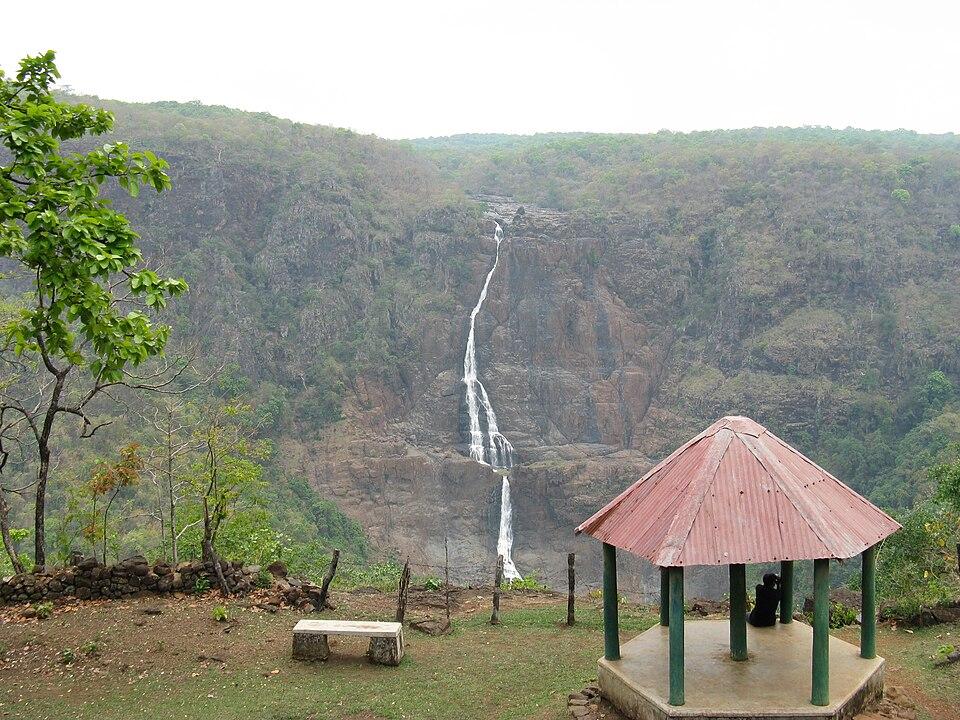
Phurlijharan is a perennial waterfall on the Sagada river, about 15 km from Bhawanipatna. The district administration gives its height as about 30 feet, while Wikipedia gives about 16 m. Sunlight often makes rainbows in the spray.

Rabandhara

Rabandhara, about 10 to 13 km from Bhawanipatna, is a waterfall in a gorge of rock and forest. Odisha Tourism runs an eco-tourism site with cottages overlooking the Pengsur reservoir, from which guided treks and nature trails are offered.

Karlapat Wildlife Sanctuary

Karlapat, about 15 km from Bhawanipatna, is a sanctuary of about 175 sq km. Its forests shelter leopard and several deer species, and birds such as the Malabar trogon and great eared nightjar have been recorded, according to Odisha Tourism.

Junagarh

Junagarh, about 26 km from Bhawanipatna, was the old capital of the Kalahandi rulers. It has a fort, temples such as the Lankeswari and Dadhibaman temples, Odia inscriptions and sati pillars recording a practice of medieval times.

Asurgarh

The ruins of Asurgarh near Narla, with their ramparts and reservoir, are the district's most important archaeological site (see History).

Belkhandi

Belkhandi, about 67 km from Bhawanipatna at the meeting of the Tel and Utei rivers, has temples and the ruins of 12th-century monuments, including sculptures of the Seven Mother Goddesses.

Ampani

The Ampani hills, about 77 km from Bhawanipatna, offer wide views and forest wildlife, according to the district administration.

Dokarichanchara

Dokarichanchara, in Koksara block, is a waterfall with a Rama temple where Ram Navami is celebrated over nine days. The Gudahandi hills nearby have prehistoric rock paintings.

Thuamul Rampur

The high plateau of Thuamul Rampur, in the south of the district, is surrounded by waterfalls and gorges and is the source area of the Indravati. Odisha Tourism has described it as Kalahandi's best-kept secret.

How to reach

ModeDetails
AirUtkela airport, about 22 km from Bhawanipatna, received its first commercial flight on 31 August 2023 (IndiaOne Air to Bhubaneswar). Raipur airport is about 262 km away
RailBhawanipatna station opened on 12 August 2012 on the Lanjigarh Road–Junagarh line; the daily Bhubaneswar–Junagarh Road Express serves it.
RoadNH 26 passes through the district. Wikipedia gives the road distance from Bhubaneswar to Bhawanipatna as about 427 km; Odisha Tourism gives about 460 km to Rabandhara near Bhawanipatna

See how to reach Odisha and the best time to visit Odisha.

Temples (3)

  • Dhavalesvara and Chandi Temple
  • Manikesvari Temple
  • Paradeswar Temple · ପାରଦେଶ୍ଵର ମନ୍ଦିର

Photos and map links in the temple directory. Today's tithi, sunrise and Rahu Kala here.

Protected monuments (1)

Monuments of National Importance protected by the Archaeological Survey of India. All of Odisha.

Railway stations

9 stations and 1 halts inside the district, as mapped on OpenStreetMap; some on new lines may not yet have regular trains.

Culture and festivals

Language. About 95% of people speak Odia as their first language, much of it in the regional variety known as Kalahandia.

Dance and music. Ghumura is the signature folk dance of Kalahandi, performed with a drum made from an earthen pot. Once associated with war music, it was later patronised by the courts of Bhawanipatna and Jayapatna.

Festivals. The Chhatar Jatra of the Manikeswari temple is the district's best-known festival. Like the rest of western Odisha, Kalahandi celebrates Nuakhai, the festival of the new rice. At Lanjigarh, the Jhami Yatra, a fire-walking festival, is held in the month of Chaitra (March–April).

Crafts and GI products.

ProductDescriptionGI status
Habaspuri saree and fabricsHandloom named after Habaspur village, with motifs such as temple (kumbha), fish, flowers and turtles; revived by weavers of ChichegudaRegistered 2012
Kapadaganda shawlEmbroidered shawl of the Dongria Kondh of the Niyamgiri hills, shared by Kalahandi and RayagadaRegistered January 2024

Wikipedia also notes wood crafts from Khaipadar and jewellery set with local gemstones. See GI tags of Odisha and our page on the Sambalpuri saree.

Communities. Adivasi communities include the Kondh, among them the Dongria Kondh of the Niyamgiri hills.

Food

Kalahandi's food is based on rice, now the district's leading crop, with finger millet (mandia) eaten in porridge and cakes. The new rice of the season is first eaten at Nuakhai.

Geography and climate

Kalahandi lies in the south-west of Odisha. Its neighbours include Nuapada, Balangir, Rayagada and Nabarangpur districts. Wikipedia describes a landscape of plains, hills and mountains, with about a third of the area under dense forest.

Rivers. The Tel, a tributary of the Mahanadi, is the main river of the district, with tributaries such as the Utei, Hati, Sagada, Udanti and Rahul. The Indravati rises in the hills of Thuamul Rampur in the south of the district and flows south towards Nabarangpur and Bastar. The Upper Indravati project at Mukhiguda dams the river for power and irrigation.

Hills and forests. The district includes the high plateau of Thuamul Rampur, the Ampani hills and part of the Niyamgiri range, which it shares with Rayagada. Karlapat Wildlife Sanctuary, close to Bhawanipatna, protects a block of forest, and Wikipedia records leopard, sambar, nilgai, barking deer and mouse deer there.

Climate. Kalahandi has a hot summer, a monsoon season from June to September, and a dry, cool winter. Historically the district was prone to drought, though large areas are now irrigated.

Economy

Agriculture. Rice is the main crop. ThePrint reported in 2024 that cotton output had also grown many times over since 2000, and that more than 90% of villages now have all-weather roads. Forest produce such as mahua flowers and kendu leaves remains important.

Irrigation and power. The Upper Indravati project at Mukhiguda provides hydropower and irrigation and is credited with the district's agricultural turnaround. The last maharaja, Pratap Keshari Deo, had championed the project.

Minerals and industry. Kalahandi has deposits of bauxite and graphite and historical sources of gemstones. Vedanta operates an alumina refinery at Lanjigarh.

Education. Kalahandi University in Bhawanipatna grew out of Kalahandi Science College, founded in 1960.

Climate of Kalahandi

In Kalahandi district (at 19.91°N, 83.16°E), the hottest month is May (average highs of 40°C) and the coolest nights come in Jan (16°C). About 1480 mm of rain falls in a year, most of it in the monsoon; Jul is the wettest month.

JanFebMarAprMayJunJulAugSepOctNovDec
Average high (°C)283136394034303030302927
Average low (°C)161822252827252424221916
Rainfall (mm)129151840209410388256872216
Rainy days1122314222218821

Averages for 1995–2024 at that point (255 m above sea level), from the Open-Meteo historical weather API (ERA5 reanalysis by ECMWF/Copernicus, CC BY 4.0) — modelled values on a ~25 km grid, not station readings from the India Meteorological Department. A rainy day has 2.5 mm or more.

Notable people

  • Pratap Keshari Deo (1919–2001): last ruler of Kalahandi (1939–1947) and Lok Sabha member for Kalahandi (1957–1980).
  • Bhubaneswar Behera (1916–2001): engineer, educationist and Odia writer, born at Kashibahal; Principal of REC Rourkela and Vice-Chancellor of Sambalpur University.
  • Kishen Pattnaik (born 1930): socialist thinker and writer, born in Bhawanipatna; Lok Sabha member (1962–1967) who raised the issue of starvation in Kalahandi.

Blocks, sub-districts, panchayats & villages

Choose a block, sub-district or town to see its details and its gram panchayats and villages. Open any village for its own page.

Counts below: Local Government Directory, December 2022 snapshot (LGD villages, which can differ from the district administration's revenue-village count).

Blocks
13
Sub-districts
13
GPs
310
LGD villages
2,257

Community development block

Bhawanipatna

Gram panchayats
36
Villages
289
LGD block code
3409
District
Kalahandi
Open full block page

Villages (…)

All blocks in Kalahandi

BlockGPsVillagesVillage pop.LiteracyST share
Bhawanipatna362891,69,98157.3%33.4%
Dharamagarh24791,35,10155.6%17.5%
Golamunda281281,30,08555.2%24.4%
Jayapatna22941,24,88753.5%40.0%
Junagarh341691,71,50156.1%17.5%
Kalampur115560,07559.7%26.1%
Karlamunda126257,41867.9%14.6%
Kesinga261111,16,77464.1%27.1%
Kokasara22731,23,43256.7%33.6%
Lanjigarh2647393,13447.3%45.4%
Madanpur Rampur1924972,63261.4%42.7%
Narala261761,21,34767.2%26.9%
Thuamul Ram Pur2429877,84045.0%58.2%

GPs and villages: Local Government Directory (Dec 2022). Village population, literacy and Scheduled Tribe share: sum of the block's villages in Census of India 2011, Primary Census Abstract (village level).

All census sub-districts

Towns (urban local bodies)

  • Bhawanipatna · Municipality
  • Dharmagarh · Notified Area Council · no matching Census 2011 town
  • Junagarh · Notified Area Council
  • Kesinga · Notified Area Council

Assembly constituencies in Kalahandi

Source: Local Government Directory (lgdirectory.gov.in), Government of India — data dump of December 2022 via github.com/planemad/india-local-government-directory. Sub-districts follow the Local Government Directory, which for Odisha uses the Census sub-districts (police-station areas) — these are not the same as revenue tahasils. Boundaries and names change over time; check the district administration for current status.

Frequently asked questions

What is the headquarters of Kalahandi district?

Bhawanipatna is the headquarters of Kalahandi district. It was also the capital of the former princely state of Kalahandi, whose earlier capital was Junagarh.

Why is Kalahandi famous?

Kalahandi is known for the ancient fortified site of Asurgarh, the Manikeswari temple and its Chhatar Jatra, Ghumura dance, Habaspuri weaving and waterfalls such as Phurlijharan. Once associated with drought and hunger, it has become a major rice-growing district since the Indravati irrigation project.

What is Asurgarh?

Asurgarh, near Narla in Kalahandi, is the site of an early fortified urban settlement of about 24 hectares with four gates. Excavations found coins from the pre-Mauryan to Gupta periods; sources differ on how far back the settlement goes.

How do I reach Bhawanipatna?

Bhawanipatna has a railway station (opened in 2012) with trains to Bhubaneswar, and Utkela airport, about 22 km away, began regional flights to Bhubaneswar in August 2023. By road, Bhubaneswar is roughly 430 to 460 km away, depending on the route and source.

Sources & references

  1. 1Tourist Places of Kalahandi — District Administration, Kalahandi, Government of Odisha
  2. 2History | Nuapada District (history of undivided Kalahandi) — District Administration, Nuapada, Government of Odisha
  3. 3Kalahandi District: Census 2011 data — Census2011.co.in (compiled from Census of India 2011)
  4. 4Rabandhara Eco Tourism — Odisha Tourism, Government of Odisha
  5. 5Once known for hunger deaths, Kalahandi is catching up fast — ThePrint
  6. 6Utkela airport in Odisha's Kalahandi gets first flight — ANI
  7. 7Kalahandi district — Wikipedia
  8. 8Bhubaneswar Behera — Wikipedia

Last reviewed . How we check articles

Report an error