Skip to content

Kendujhar district

କେନ୍ଦୁଝର ଜିଲ୍ଲା

Kendujhar (Keonjhar) district in north Odisha: iron ore hub, Maa Tarini at Ghatagaon, Gonasika, Sitabinji frescoes and waterfalls.

Headquarters
Kendujhar
Population (2011)
1,801,733
Area
8,303 sq km
Villages
2,128
Literacy (2011)
68.2%
Towns (2011)
9

Kendujhar (କେନ୍ଦୁଝର), also spelled Keonjhar, is a hilly, forested district in northern Odisha whose headquarters is Kendujhar town. Kendujhar district is one of India's main iron ore regions and is also known for the Maa Tarini shrine at Ghatagaon, the source of the Baitarani river at Gonasika and the ancient paintings at Sitabinji.

Kendujhar lies on the northern plateau of Odisha, bordering Jharkhand. It covers 8,303 sq km and had a population of 1,801,733 in the 2011 Census. Scheduled Tribes formed about 45.5 percent of the population. The largest groups are the Ho, Bhuyan, Munda and Santal, and the district is the main home of the Juang, a Particularly Vulnerable Tribal Group.

The district was formed from the former princely state of Keonjhar, which merged with India on 1 January 1948. It has three sub-divisions: Kendujhar, Champua and Anandapur, with 13 blocks.

Kendujhar's economy is dominated by mining. The Joda–Barbil belt in the north is among the most important iron ore and manganese areas in India. The rest of the district is largely rural, with forests, hills and many waterfalls.
People of Kendujhar district

Census 2011 counted 18,01,733 people in 4,05,272 households in Kendujhar district. 14.0% lived in towns, and the literacy rate (age 7 and over) was 68.2%. The census recognised 9 towns in the district.

Population
18,01,733
9,06,487 male · 8,95,246 female
Households
4,05,272
about 4.4 people each
Literacy (age 7+)
68.2%
men 78.1% · women 58.3%
Females per 1,000 males
988
Girls per 1,000 boys (0–6)
967
People per km²
217
  • Rural15,48,674 (86.0%)
  • Urban2,53,059 (14.0%)
Scheduled Castes
2,09,357 (11.6%)
Scheduled Tribes
8,18,878 (45.4%)

What the 7,66,514 workers did

  • Cultivators1,58,838 (20.7%)
  • Agricultural labourers84,638 (11.0%)
  • Household industry12,007 (1.6%)
  • Other work1,87,014 (24.4%)
  • Marginal workers3,24,017 (42.3%)

Marginal workers worked less than six months of the year.

Source: Census of India 2011, Primary Census Abstract (district, sub-district and town level). Figures are from 2011, the most recent census with published district, town and village figures.

Facilities in the villages of Kendujhar

How many of the 2,064 inhabited villages of this district had each facility within the village itself, from the Census 2011 Village Directory. Together the 2,123 villages cover 6,336 km², 24% of it sown with crops and 24% forest.

Education

  • Primary school1,951 of 2,064
  • Middle school1,134 of 2,064
  • Secondary school745 of 2,064
  • Senior secondary school77 of 2,064
  • Degree college66 of 2,064

Health

  • Primary health centre4 of 2,064
  • Health sub-centre329 of 2,064
  • Anganwadi centre2,026 of 2,064

Water & power

  • Treated tap water0 of 2,064
  • Hand pump1,966 of 2,064
  • Electricity for homes1,426 of 2,064

Roads & transport

  • All-weather road1,090 of 2,064
  • Public bus278 of 2,064
  • Mobile phone coverage1,972 of 2,064

Services

  • Post office or sub post office738 of 2,064
  • Commercial bank0 of 2,064
  • Ration (PDS) shop515 of 2,064
  • Weekly haat288 of 2,064
Primary schools
2,214
Middle schools
1,162
Secondary schools
838
Degree colleges
66
Primary health centres
13
Health sub-centres
329

Main crops named by villages: Paddy (1,917), Vegetables (251), Oilseed (204), Sesame (134), Wheat (48), Vegetable (47), Maize (27), Pulses (24).

Source: Census of India 2011, District Census Handbook: Village and Town Directory (Odisha). The facilities were recorded for the 2011 census (reference year 2009 for most items); many places have changed since. Facilities in towns are not included.

Towns of Kendujhar

4 statutory towns (municipal corporation, municipality, notified area council or industrial township) and 5 census towns — places the census counted as urban but which are governed by gram panchayats.

TownTypePopulationLiteracyWards
BarbilMunicipality66,54072.2%15
KendujharMunicipality60,59087.2%21
JodaMunicipality46,63172.2%14
AnandpurMunicipality39,58584.5%16
Balagoda (Bolani)Census town11,70871.9%–
ChampuaCensus town10,39487.0%–
JajangaCensus town7,48260.8%–
JhumpuraCensus town6,06482.7%–
DaitariCensus town4,06582.8%–

Population of the town itself; for towns with outgrowths, the town page also gives the figure including them. Ward counts are the census wards of 2011.

Census sub-districts: town and country

Sub-districtPopulationRuralUrbanLiteracy
Barbil84,13017,59066,54068.9%
Bolani19,9938,28511,70866.2%
Rugudi16,56016,560060.8%
Joda72,69826,06746,63166.5%
Bamebari56,27148,7897,48253.9%
Champua97,11786,72310,39468.5%
Jhumpura46,93640,8726,06466.6%
Baria73,66473,664069.2%
Turumunga68,59868,598069.8%
Patana1,04,8241,04,824065.6%
Kendujhar Sadar1,57,4141,57,414063.5%
Kendujhar Town98,88038,29060,59080.4%
Nayakote46,05646,056040.8%
Kanjipani21,74121,741039.4%
Telkoi95,71895,718065.8%
Pandapara63,30863,308065.2%
Ghatgaon1,07,1061,07,106065.5%
Harichandanpur80,71180,711064.3%
Daitari27,57123,5064,06551.7%
Ghasipura1,12,7401,12,740074.7%
Anandapur1,24,21884,63339,58570.0%
Soso64,24464,244072.3%
Nandipada82,54282,542086.5%
Sainkul78,69378,693082.0%

Odisha's census sub-districts are police-station areas, not revenue tahasils.

History

According to Wikipedia's summary of the district's history, the Nagas of Vindhyatabi ruled the area from about the 2nd to the 4th century CE. An inscription at Sitabinji names a king, Maharaja Sri Disabhanja, and is dated by scholars to around the 4th–5th century CE.

The district administration records that Keonjhar became a separate state in the first half of the 12th century, when Jyoti Bhanja, of the Bhanja family of Khijjinga (Mayurbhanj), became its ruler; Wikipedia adds that he was installed with the support of local Bhuyan clans. In the late 15th century Govinda Bhanja greatly enlarged the state. During the reign of Pratap Balabhadra Bhanja (1764–1792), the small tracts of Tillo and Jujhpada were added. They were recognised as part of Keonjhar in the sanad that the East India Company granted to Raja Janardan Bhanja in 1804.

In 1891 the Bhuyan people and other communities rose against Raja Dhanurjaya Bhanja over forced labour and other burdens. The revolt, remembered as the Bhuyan Meli or Dharani Meli, was led by Dharanidhar Naik. For a time the king fled to Cuttack, but British forces eventually suppressed the uprising, and Dharanidhar was imprisoned in Cuttack until 1897. After his release he withdrew from public life and lived at a hermitage at Ali until his death in 1914.

In 1931 the state covered about 8,019 sq km and had 460,609 people, according to Wikipedia. The last ruler, Balabhadra Narayan Bhanj Deo, reigned from 1926. Keonjhar merged with India on 1 January 1948 and became a district of Odisha.

Places to visit

Maa Tarini Temple, Ghatagaon

The shrine of Maa Tarini at Ghatagaon is one of the most visited pilgrimage centres in northern Odisha. It is about 45 km from Keonjhar town and 180 km from Bhubaneswar. Devotees offer coconuts to the goddess, and the district administration notes that tribal priests continue to serve here. Maha Bisuba Sankranti is celebrated with special festivities.

Gonasika

Gonasika, in the hills where the Baitarani rises, is a sacred place with the Brahmeswar Mahadev temple. The district administration says the Baruni Jatra here in Chaitra draws about 30,000 pilgrims.

Sanaghagara and Badaghagara waterfalls

These two waterfalls lie close to Keonjhar town. The district administration places Sanaghagara about 8 km from the town on the national highway. Odisha Tourism describes Badaghagara as the larger fall, dropping roughly 100 ft through forest.

Khandadhar Waterfall

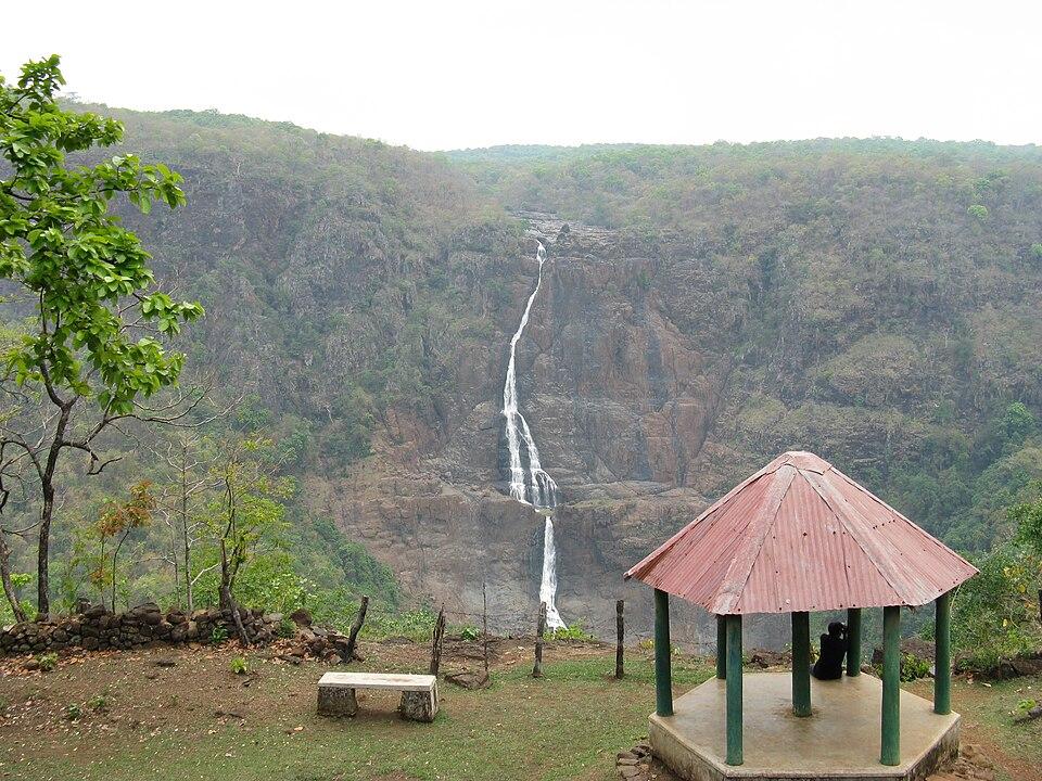
This Khandadhar, not to be confused with the waterfall of the same name in Sundargarh district, is described by the district administration as one of the most beautiful waterfalls in the state. The administration puts it 50–60 km from Keonjhar town.

Sitabinji

The Sitabinji group of rock shelters, about 30 km south of Keonjhar town near the Sita river, is protected by the Archaeological Survey of India. On a boulder called Ravana Chhaya is a painting of a royal procession with a king on an elephant. Painted in tempera and usually dated to the 4th–5th century CE, it is regarded as one of the earliest Indian paintings on a non-religious subject.

Nomira pillow lava

Near Nomira village, about 18 km south of Joda, rare pillow lava formed when molten lava erupted and cooled under water. OrissaPOST reports that the Geological Survey of India declared it a national geological monument in 1976 and dates the rocks to about 2.8 billion years.

Other sites

  • Kushaleswar temple, Deogaon: a Shiva shrine that the district administration dates to about 900 CE.
  • Murga Mahadev temple: at the foot of the Thakurani hills, beside a perennial spring.
  • Kanjipani Ghati: a scenic mountain road with wide views; the district administration says the ghat trail runs for about 20 km.
  • Keshari Kunda: two natural holes in the bed of the Baitarani where pilgrims take a holy dip.
  • Bhimkund: a pool and waterfall on the Baitarani, set among rocks and forest.
  • Hadagarh reservoir: a dam on the Salandi river in the Anandapur sub-division.
  • Handibhanga and Gundichaghagi: forest waterfalls; Gundichaghagi is a series of cascades on the Musala river.

How to reach

  • By air: The district administration gives the distance to Biju Patnaik International Airport, Bhubaneswar, as about 230 km.
  • By rail: Kendujhargarh station, on the Padapahar–Jakhapura line, has had passenger services since 2009, including MEMU trains towards Bhubaneswar. Jajpur Keonjhar Road on the Howrah–Chennai main line is another option, and Harichandanpur is the nearest station for Ghatagaon.
  • By road: National highways NH-49, NH-20, NH-215, NH-520 and NH-220 run through the district, connecting it with Bhubaneswar, Cuttack, Jamshedpur and Kolkata.

See also how to reach Odisha and the Odisha map.

Temples (3)

  • Baladevjiu Temple
  • Kosalesvara Temple
  • Maa Tarini Temple, Ghatgaon · ତାରିଣୀ ମନ୍ଦିର

Photos and map links in the temple directory. Today's tithi, sunrise and Rahu Kala here.

Protected monuments (1)

Monuments of National Importance protected by the Archaeological Survey of India. All of Odisha.

Railway stations

19 stations and 0 halts inside the district, as mapped on OpenStreetMap; some on new lines may not yet have regular trains.

Culture and festivals

The district administration describes a wide festival calendar. It includes Nuakhai, Raja and Makar Sankranti, Shivaratri at the Shiva temples, Bodam in the month of Pousha, and tribal festivals such as Sohrai and Karma. During Chaitra Parba, Chhau is performed.

Dance is part of community life. The district site mentions Changu dance with drums, the Juang dance, Ho dances during the Magh festival and Chhau.

The Juang live mainly in Banspal block. The state's tribal research institute (SCSTRTI) notes that the name means "man" in their own Munda-family language. They traditionally centre village life on the mandaghar, a youth dormitory. A Juang Development Agency was set up at Gonasika in 1978–79.

Odia is the main language, spoken by about 79 percent of people in 2011, followed by Ho and Santali.

Geography and climate

According to the district administration, Kendujhar is bounded by Mayurbhanj and Bhadrak to the east, Jajpur to the south, Dhenkanal and Sundargarh to the west, and West Singhbhum district of Jharkhand to the north.

The district is hilly, with several peaks above 900 m:

HillHeight (approx.)
Mankadnacha3,639 ft
Gandhamardan3,477 ft
Gonasika3,219 ft
Thakurani3,003 ft

The Baitarani river rises in the Gonasika hills. Its source is a rock shaped like a cow's nose, which gives the place its name. The river first flows north, then turns east and briefly forms the boundary with Jharkhand. Tropical deciduous forest covers much of the district.

Kendujhar has hot summers and a strong monsoon. Wikipedia gives an average annual rainfall of about 1,910 mm for the district, with summer highs of over 43°C and cold winter nights. Kendujhar town has recorded extremes of about 47.4°C in May and 2.2°C in winter, and receives about 1,419 mm of rain a year, most of it between June and September.

Economy

Mining is the backbone of the district's economy. Iron ore, manganese and chromite are worked around Joda, Barbil, Banspani and Barjamda by the Odisha Mining Corporation, Tata Steel and other companies. Wikipedia's summary states that Kendujhar supplies about 30 percent of Odisha's iron ore and most of its manganese.

Outside the mining belt, most people depend on farming and forest produce. In 2006 the Ministry of Panchayati Raj listed Kendujhar among India's backward districts receiving the Backward Regions Grant Fund.

Climate of Kendujhar

In Kendujhar district (at 21.63°N, 85.58°E), the hottest month is Apr (average highs of 35°C) and the coolest nights come in Jan (13°C). About 1600 mm of rain falls in a year, most of it in the monsoon; Aug is the wettest month.

JanFebMarAprMayJunJulAugSepOctNovDec
Average high (°C)252832353532292929282625
Average low (°C)131620232525242423211713
Rainfall (mm)202231441102643513752421121515
Rainy days2245918252621921

Averages for 1995–2024 at that point (483 m above sea level), from the Open-Meteo historical weather API (ERA5 reanalysis by ECMWF/Copernicus, CC BY 4.0) — modelled values on a ~25 km grid, not station readings from the India Meteorological Department. A rainy day has 2.5 mm or more.

Notable people

  • Dharanidhar Naik (1864–1914), born at Kusumita, leader of the 1891 Bhuyan uprising. Keonjhar's college, now Dharanidhar University (university status 2023), was renamed after him in 1983–84.
  • Mohan Charan Majhi, born in 1972 at Raikala village, MLA for Keonjhar, and Chief Minister of Odisha from 12 June 2024.

Blocks, sub-districts, panchayats & villages

Choose a block, sub-district or town to see its details and its gram panchayats and villages. Open any village for its own page.

Counts below: Local Government Directory, December 2022 snapshot (LGD villages, which can differ from the district administration's revenue-village count).

Blocks
13
Sub-districts
24
GPs
297
LGD villages
2,128

Community development block

Anandapur

Gram panchayats
18
Villages
124
LGD block code
3443
District
Kendujhar
Open full block page

Villages (…)

All blocks in Kendujhar

BlockGPsVillagesVillage pop.LiteracyST share
Anandapur181241,08,62564.4%49.1%
Bansapal211611,01,25442.3%79.4%
Champua2214499,98269.4%47.7%
Ghasipura251661,49,59878.4%20.2%
Ghatgaon271421,18,30766.4%63.3%
Harichadanpur252191,37,74761.7%56.8%
Hatadihi312231,64,62980.8%18.2%
Jhumpura221521,06,47961.8%53.1%
Joda191201,04,73756.9%63.2%
Kendujhar Sadar252261,63,20468.1%50.5%
Patana201541,01,85667.5%52.5%
Saharapada2014088,48465.7%58.2%
Telkoi2214996,59065.4%52.2%

GPs and villages: Local Government Directory (Dec 2022). Village population, literacy and Scheduled Tribe share: sum of the block's villages in Census of India 2011, Primary Census Abstract (village level).

All census sub-districts

Towns (urban local bodies)

  • Anandapur · Municipality
  • Barbil · Municipality
  • Champua · Notified Area Council · no matching Census 2011 town
  • Joda · Municipality
  • Kendujhar · Municipality

Assembly constituencies in Kendujhar

Source: Local Government Directory (lgdirectory.gov.in), Government of India — data dump of December 2022 via github.com/planemad/india-local-government-directory. Sub-districts follow the Local Government Directory, which for Odisha uses the Census sub-districts (police-station areas) — these are not the same as revenue tahasils. Boundaries and names change over time; check the district administration for current status.

Frequently asked questions

Is Kendujhar the same as Keonjhar?

Yes. Kendujhar is the official Odia-based spelling and Keonjhar the older English form. Both names are used for the district and its headquarters town.

What is Keonjhar famous for?

Keonjhar is known for its large iron ore and manganese mines around Joda and Barbil, the Maa Tarini temple at Ghatagaon, Gonasika where the Baitarani river rises, the Sitabinji rock painting and waterfalls such as Sanaghagara, Badaghagara and Khandadhar.

How far is Ghatagaon Tarini temple from Keonjhar?

The district administration gives the distance as about 45 km from Keonjhar town and about 180 km from Bhubaneswar. The nearest railway station is Harichandanpur, about 17 km away.

Who was Dharanidhar Naik?

Dharanidhar Naik (1864–1914) led the Bhuyan uprising of 1891 in Keonjhar State against forced labour and other exactions. Dharanidhar University in Keonjhar town is named after him.

Sources & references

  1. 1Kendujhar District: Census 2011 data — Census2011.co.in (compiled from Census of India 2011)
  2. 2History — District Administration, Kendujhar, Government of Odisha
  3. 3Maa Tarini Pitha Ghatagaon — District Administration, Kendujhar (NIC)
  4. 4Culture & Heritage — District Administration, Kendujhar (NIC)
  5. 5How to Reach — District Administration, Kendujhar (NIC)
  6. 6Juang — SCSTRTI, Government of Odisha
  7. 7Geo-heritage tag for Nomira — OrissaPOST
  8. 8Kendujhar district — Wikipedia

Last reviewed . How we check articles

Report an error