Skip to content

Khordha district

ଖୋର୍ଦ୍ଧା ଜିଲ୍ଲା

Khordha district holds Odisha's capital Bhubaneswar. Formed in 1993, it is known for Kalinga temples, Dhauli, the Paika Rebellion and Chilika's shore.

Headquarters
Khordha
Population (2011)
2,251,673
Area
2,813 sq km
Villages
1,569
Literacy (2011)
86.9%
Towns (2011)
13

Khordha (ଖୋର୍ଦ୍ଧା), also spelled Khurda or Khurdha, is a district in coastal Odisha that contains Bhubaneswar, the state capital. The district headquarters, however, is the historic town of Khordha, about 25 km south-west of Bhubaneswar.

Khordha is best known for the temple city of Bhubaneswar, the Kalinga War site at Dhauli, the Jain caves of Udayagiri and Khandagiri, and its role in Odisha's resistance to British rule: Khurda was the seat of the last independent Odia kingdom, and the centre of the Paika Rebellion of 1817.

The district came into existence on 1 April 1993, when the old Puri district was split into Puri, Khordha and Nayagarh districts. Wikipedia notes that the name was standardised as Khordha in 2000. It has two sub-divisions, Khordha and Bhubaneswar.

At the 2011 Census, Khordha had 2,251,673 people on 2,813 sq km, with about 800 people per sq km. It is Odisha's most urbanised district: about 48% of residents lived in towns, and literacy stood at 86.88%.

People of Khordha district

Census 2011 counted 22,51,673 people in 4,94,212 households in Khordha district. 48.2% lived in towns, and the literacy rate (age 7 and over) was 86.9%. The census recognised 13 towns in the district.

Population
22,51,673
11,67,137 male · 10,84,536 female
Households
4,94,212
about 4.6 people each
Literacy (age 7+)
86.9%
men 91.8% · women 81.6%
Females per 1,000 males
929
Girls per 1,000 boys (0–6)
916
People per km²
800
  • Rural11,67,357 (51.8%)
  • Urban10,84,316 (48.2%)
Scheduled Castes
2,97,472 (13.2%)
Scheduled Tribes
1,15,051 (5.1%)

What the 7,92,193 workers did

  • Cultivators79,793 (10.1%)
  • Agricultural labourers64,072 (8.1%)
  • Household industry29,066 (3.7%)
  • Other work4,59,694 (58.0%)
  • Marginal workers1,59,568 (20.1%)

Marginal workers worked less than six months of the year.

Source: Census of India 2011, Primary Census Abstract (district, sub-district and town level). Figures are from 2011, the most recent census with published district, town and village figures.

Facilities in the villages of Khordha

How many of the 1,356 inhabited villages of this district had each facility within the village itself, from the Census 2011 Village Directory. Together the 1,534 villages cover 2,531 km², 46% of it sown with crops and 14% forest.

Education

  • Primary school1,067 of 1,356
  • Middle school634 of 1,356
  • Secondary school282 of 1,356
  • Senior secondary school48 of 1,356
  • Degree college36 of 1,356

Health

  • Primary health centre4 of 1,356
  • Health sub-centre170 of 1,356
  • Anganwadi centre1,201 of 1,356

Water & power

  • Treated tap water0 of 1,356
  • Hand pump1,314 of 1,356
  • Electricity for homes1,117 of 1,356

Roads & transport

  • All-weather road847 of 1,356
  • Public bus132 of 1,356
  • Mobile phone coverage1,317 of 1,356

Services

  • Post office or sub post office223 of 1,356
  • Commercial bank4 of 1,356
  • Ration (PDS) shop573 of 1,356
  • Weekly haat119 of 1,356
Primary schools
1,410
Middle schools
703
Secondary schools
370
Degree colleges
38
Primary health centres
5
Health sub-centres
170

Main crops named by villages: Paddy (821), Black Gram (147), Pulses (121), Cashew Nut (31), Brinjal (27), Vegetables (21), Potato (5), Pumpkin (5). Handicrafts: Iron Products (1), Baskets (1), Furnitures (1), Saree (1), Weaving (1).

Source: Census of India 2011, District Census Handbook: Village and Town Directory (Odisha). The facilities were recorded for the 2011 census (reference year 2009 for most items); many places have changed since. Facilities in towns are not included.

Towns of Khordha

5 statutory towns (municipal corporation, municipality, notified area council or industrial township) and 8 census towns — places the census counted as urban but which are governed by gram panchayats.

TownTypePopulationLiteracyWards
BhubaneswarMunicipal Corporation8,43,40291.9%81
JataniMunicipality55,92589.8%26
KhordhaMunicipality46,20592.2%22
BalugaonNotified Area Council17,64581.7%11
BanapurNotified Area Council17,27885.8%15
PratapsasanCensus town12,83086.6%–
BhakarsahiCensus town7,11086.5%–
BalipatapurCensus town6,89869.0%–
BhapurCensus town6,43886.0%–
DungamalCensus town6,27192.9%–
MajhiharaCensus town5,59886.5%–
KaipadarCensus town4,51285.2%–
TangiCensus town4,47187.4%–

Population of the town itself; for towns with outgrowths, the town page also gives the figure including them. Ward counts are the census wards of 2011.

Census sub-districts: town and country

Sub-districtPopulationRuralUrbanLiteracy
Bolagad90,79490,794084.7%
Begunia97,16697,166084.9%
Khordha1,39,97893,77346,20587.2%
Khordha Sadar62,04057,5284,51285.5%
Chandaka55,46855,468081.4%
Nandankanan17,67017,670087.5%
Mancheswar5,1175,117085.9%
Balianta91,72878,89812,83084.1%
Balipatna1,32,7961,13,65019,14684.6%
Lingaraj189189097.0%
Airfield (Kapila Prasad)13,44513,445089.5%
Uttara P.S12,94112,941084.0%
Khandagiri2,5722,572090.5%
Tamando16,40616,406090.9%
Jatani1,26,40562,70863,69787.8%
Jankia84,60884,608083.5%
Nirakarpur37,98037,980085.6%
Tangi1,52,0371,40,66811,36978.2%
Balugaon1,13,75889,84223,91681.3%
Banapur1,13,21295,93417,27878.0%
Bhubaneswar (M.Corp.)8,85,36308,85,36391.7%

Odisha's census sub-districts are police-station areas, not revenue tahasils.

History

People have lived and built in this area for well over two thousand years. Sisupalgarh, an early fortified city on the eastern edge of Bhubaneswar, is protected by the Archaeological Survey of India. Dhauli hill on the Daya is widely believed to be the site of the Kalinga War, and it bears rock edicts of the Mauryan emperor Ashoka. In the 1st century BCE the Mahameghavahana king Kharavela is associated with the rock-cut Jain caves of Udayagiri and Khandagiri.

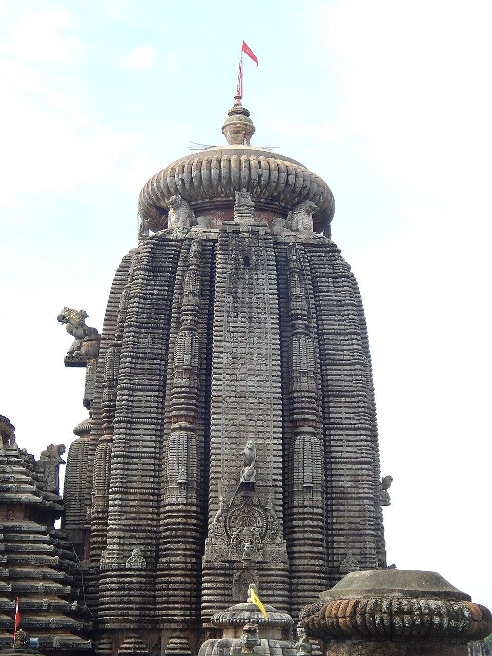
Between roughly the 7th and 13th centuries, successive dynasties built the temples of Bhubaneswar's Old Town. The Lingaraj Temple, the largest of them, dates from the late 11th century.

After the defeat of Mukunda Deva in 1568, Ramachandra Deva I of the Bhoi dynasty set up a new power centre at Khurda. The Khurda kings retained control of the Jagannath Temple at Puri, which gave them standing as the traditional rulers of Odisha even after the Marathas took most of the region in the 18th century. Wikipedia describes Khurda as the seat of Odisha's kings from 1568 to 1803.

The East India Company took Odisha in 1803. After a failed revolt by King Mukunda Deva II, the Company annexed Khurda in 1804. His minister and royal priest Jayee Rajguru was executed at Midnapore on 6 December 1806, and many in Odisha remember him as one of the earliest martyrs of resistance to British rule.

In 1817 the Paikas, the traditional militia of Khurda, rose against the Company's land and salt policies under Buxi Jagabandhu. The Paika Rebellion spread to Puri and beyond before it was suppressed. Jagabandhu held out until 1825.

In the 20th century Bhubaneswar was chosen as the capital of the new state, replacing Cuttack in 1948. Bhubaneswar and Khurda remained sub-divisions of Puri district until Khordha district was created in 1993.

Places to visit

Bhubaneswar Old Town temples

Around the Bindu Sagar tank stand the Lingaraj Temple, Mukteswar, Parasurameswar and Rajarani temples, among many others. They make the city one of the best places in India to see the evolution of the Kalinga style of temple architecture. Entry to the Lingaraj sanctum is restricted to Hindus. See the Bhubaneswar travel guide.

Udayagiri and Khandagiri

These twin sandstone hills on the western edge of Bhubaneswar hold rock-cut chambers made for Jain monks. They include the Hathigumpha inscription of Kharavela. Read more about Udayagiri and Khandagiri.

Dhauli

Dhauli hill, about 8 km south of Bhubaneswar, has Ashokan rock edicts and a white Peace Pagoda (Shanti Stupa), which was built in 1972 with Japanese Buddhist support.

Nandankanan Zoological Park

Nandankanan was inaugurated on 29 December 1960 and spreads over about 437 hectares around Kanjia Lake, between Bhubaneswar and Cuttack. It is known for breeding white tigers since 1980, and in 2009 it became the first Indian zoo to join the World Association of Zoos and Aquariums. The park is closed on Mondays.

Atri hot spring

Atri, about 15 km west of Khordha town, has a perennial hot spring of about 57 °C and the temple of Hatakeswar (Shiva). The ENVIS eco-heritage centre records a large fair here on Makar Sankranti.

Barunei hill

The hill near Khordha town has a shrine to the twin goddesses Barunei and Karunei and a hill stream, the Swarna Ganga. Raja Parba is the main festival at the temple.

Mangalajodi and Chilika

Mangalajodi, in Tangi block on the northern edge of Chilika, is a community-protected wetland. Former bird hunters now guide visitors by boat, and peak winter counts have topped 150,000 birds. Barkul, near Balugaon, is another base for boat trips on the lake. See the Chilika Lake travel guide.

Banapur

Banapur, near Chilika in the south of the district, is known for its Bhagabati temple, which is regarded as a Shakti pitha. The town also celebrates Panchudola, a festival held five days after Dola Purnima in which deities from nearby villages are carried in procession. Banapur was also a centre of the 1817 rising.

How to reach

  • By air: Biju Patnaik International Airport is in Bhubaneswar itself, inside the district.
  • By rail: Bhubaneswar and Khurda Road Junction are on the main Howrah–Chennai line, with the branch to Puri leaving from Khurda Road.
  • By road: National Highway 16 (Kolkata–Chennai) runs through Bhubaneswar and Khordha town. Khordha town is about 25 km from Bhubaneswar, and Tangi, the access town for Mangalajodi, is about 60 km.

For connections from other states see how to reach Odisha, and for nearby districts see Puri, Cuttack and Nayagarh.

Temples (165)

  • Aisanyesvara Siva Temple · ଐଶାଣେଶ୍ଵର ଶିବ ମନ୍ଦିର
  • Aishanyesvara Temple
  • Akhadachandi Temple · ଆଖଡ଼ଚଣ୍ଡୀ ମନ୍ଦିର
  • Akhandalesvara Temple
  • Ananta Vasudeva Temple · ଅନନ୍ତ ବାସୁଦେବ ମନ୍ଦିର
  • Anantavasudeva Temple
  • Arjunesvara Siva Temple
  • Astasambhu Siva Temples · ଅଷ୍ଟଶମ୍ଭୁ ଶିବ ମନ୍ଦିର
  • Baitala Deula · ବଇତାଳ ଦେଉଳ
  • Bakeswar temple
  • Bakresvara Temple
  • Balaram Temple
  • Bata Mahadeva temple · ବାଟ ମହାଦେବ, ଭୁବନେଶ୍ଵର
  • Beharana Mandapa
  • Belesvara Siva Temple
  • Bhabanisankara Temple
  • Bhabni Shankar Temple
  • Bhagavati Temple
  • Bhairangesvara Temple
  • Bhandara Ghara Shrine
  • Bharateswar Temple · ଭରତେଶ୍ୱର ମନ୍ଦିର, ଭୁବନେଶ୍ୱର
  • Bharati Matha Temple · ଭାରତୀ ମଠ ମନ୍ଦିର
  • Bhaskareswar Temple · ଭାସ୍କରେଶ୍ୱର ମନ୍ଦିର
  • Bhavani Shiva Temple · ଭବାନୀଶଙ୍କର ମନ୍ଦିର

And 141 more. Photos and map links in the temple directory. Today's tithi, sunrise and Rahu Kala here.

Protected monuments (27)

Monuments of National Importance protected by the Archaeological Survey of India. All of Odisha.

Railway stations

14 stations and 10 halts inside the district, as mapped on OpenStreetMap; some on new lines may not yet have regular trains.

Culture and festivals

Khordha's festival calendar centres on Bhubaneswar's temples. The Lingaraj Temple celebrates Maha Shivaratri, Ashokastami (the Rukuna Rath chariot procession) and a 22-day Chandan Yatra at Bindu Sagar. Each winter the city hosts the Mukteswar Dance Festival, which features Odissi, and the Rajarani Music Festival.

Durga Puja in Bhubaneswar is known for its themed pandals and for the burning of Ravana effigies on Dussehra. Raja Parba and Makar Sankranti are widely observed in the villages. The Ekamra Haat market in Bhubaneswar is the easiest place to find handloom and crafts from across Odisha, including Sambalpuri sarees and Pipili appliqué.

Food

As the capital district, Khordha has restaurants serving food from across Odisha, including dalma, pakhala bhata and dahibara aloodum. Pahala, a roadside sweet market on National Highway 16 between Bhubaneswar and Cuttack, is well known for rasagola, chhena gaja and chhena poda. Kora khai, a sweet of puffed paddy and jaggery, is commonly associated with Bhubaneswar's temple fairs.

Geography and climate

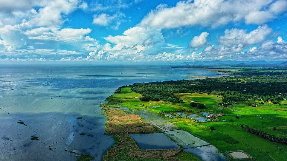
Khordha lies on the edge of the Mahanadi delta between the coastal plain and the low, forested hills of the Eastern Ghats. It borders Cuttack district to the north, Puri district to the east, Nayagarh to the west and Ganjam to the south-west. In the south the district touches the north-western shore of Chilika Lake, around Balugaon, Barkul and Tangi.

The Daya and Kuakhai rivers flow through the district. Dhauli stands on the bank of the Daya. Wikipedia gives the district's forest area as about 619 sq km. The forests of the Chandaka-Dampara Wildlife Sanctuary, notified in December 1982 and covering about 176 sq km of the Khurda uplands, lie on the north-western edge of Bhubaneswar and are known for their elephants.

FeatureDetail
LocationCoastal central Odisha, between the Mahanadi delta and Chilika
RiversDaya, Kuakhai
WetlandsNorth-western shore of Chilika Lake (Ramsar site since 1981)
Protected areaChandaka-Dampara Wildlife Sanctuary (1982)
RainfallRoughly 1,200 to 1,450 mm a year, mostly in the June to September monsoon

The climate is tropical. Summers from March to June are very hot, the south-west monsoon brings most of the rain, and winters from November to February are mild and dry.

Economy

Bhubaneswar dominates the district economy as Odisha's administrative, education and services centre, with a growing information-technology sector. Khurda Road is the headquarters of an East Coast Railway division. Wikipedia lists brass utensils, cottage industries and cable manufacturing among the district's traditional and modern industries, along with large food and beverage plants. Outside the city, farming (mainly paddy) remains important, and families near Chilika depend on fishing and, increasingly, on nature tourism.

Climate of Khordha

In Khordha district (at 20.18°N, 85.62°E), the hottest month is May (average highs of 36°C) and the coolest nights come in Jan (16°C). About 1550 mm of rain falls in a year, most of it in the monsoon; Jul is the wettest month.

JanFebMarAprMayJunJulAugSepOctNovDec
Average high (°C)273134363634313131302927
Average low (°C)161923262727262625232016
Rainfall (mm)14142422602063743582671473527
Rainy days11224152425211132

Averages for 1995–2024 at that point (40 m above sea level), from the Open-Meteo historical weather API (ERA5 reanalysis by ECMWF/Copernicus, CC BY 4.0) — modelled values on a ~25 km grid, not station readings from the India Meteorological Department. A rainy day has 2.5 mm or more.

Notable people

  • Buxi Jagabandhu Bidyadhar: military commander of the Khurda kingdom and leader of the Paika Rebellion of 1817.
  • Godabarish Mishra (1886–1956): poet, educationist and politician, born at Srinibaspur Sasan in present-day Khordha district. He belonged to the circle of Gopabandhu Das at the Satyabadi school.
  • Ranganath Misra (born 1926): born at Banapur, he was Chief Justice of India from 1990 to 1991.

Jayee Rajguru, the Khurda minister executed in 1806, was born near Puri; see the Puri district page.

Blocks, sub-districts, panchayats & villages

Choose a block, sub-district or town to see its details and its gram panchayats and villages. Open any village for its own page.

Counts below: Local Government Directory, December 2022 snapshot (LGD villages, which can differ from the district administration's revenue-village count).

Blocks
10
Sub-districts
22
GPs
190
LGD villages
1,569

Community development block

Balianta

Gram panchayats
16
Villages
98
LGD block code
3456
District
Khordha
Open full block page

Villages (…)

All blocks in Khordha

BlockGPsVillagesVillage pop.LiteracyST share
Balianta169897,48284.1%1.1%
Balipatna178895,06684.0%0.1%
Banapur172581,25,44578.3%8.7%
Begunia211731,31,39385.4%11.2%
Bhubaneswar2011994,66884.7%10.7%
Bolagarh192361,31,78984.8%6.8%
Chilika171381,14,10079.2%0.7%
Jatni1511593,56286.1%7.8%
Khordha221331,29,43283.9%8.0%
Tangi262101,56,13480.6%2.3%

GPs and villages: Local Government Directory (Dec 2022). Village population, literacy and Scheduled Tribe share: sum of the block's villages in Census of India 2011, Primary Census Abstract (village level).

All census sub-districts

Towns (urban local bodies)

Tehsil guides

Assembly constituencies in Khordha

Source: Local Government Directory (lgdirectory.gov.in), Government of India — data dump of December 2022 via github.com/planemad/india-local-government-directory. Sub-districts follow the Local Government Directory, which for Odisha uses the Census sub-districts (police-station areas) — these are not the same as revenue tahasils. Boundaries and names change over time; check the district administration for current status.

Frequently asked questions

Is Bhubaneswar in Khordha district?

Yes. Bhubaneswar, the capital of Odisha, lies in Khordha district, but the district headquarters is Khordha town, about 25 km from Bhubaneswar.

When was Khordha district formed?

Khordha district came into existence on 1 April 1993, when the old Puri district was divided into Puri, Khordha and Nayagarh districts.

Why is Khordha important in Odisha's history?

Khurda was the seat of the Bhoi kings from 1568, who kept a link with the Jagannath Temple, and it was the centre of the Paika Rebellion of 1817 against the East India Company, led by Buxi Jagabandhu.

What are the main places to visit in Khordha district?

The Old Town temples of Bhubaneswar, Udayagiri and Khandagiri caves, Dhauli, Nandankanan Zoological Park, the Atri hot spring, Barunei hill and the Mangalajodi wetlands on Chilika.

How many blocks are there in Khordha district?

Khordha district has two sub-divisions (Khordha and Bhubaneswar) and 10 community development blocks, according to Wikipedia's district summary. The full block list appears on this page.

Sources & references

  1. 1Khordha district — Wikipedia
  2. 2Khordha District at a Glance — District Administration, Khordha, Government of Odisha
  3. 3Districts of Orissa – Census 2011 population — Census2011.co.in (compiled from Census of India 2011)
  4. 4Bhoi dynasty — Wikipedia
  5. 5Jayee Rajguru — Wikipedia
  6. 6Atri — CPREEC ENVIS Centre on Eco-heritage (Ministry of Environment, Forest and Climate Change)
  7. 7Mangalajodi — Wikipedia
  8. 8Nandankanan Zoological Park — Wikipedia

Last reviewed . How we check articles

Report an error