Skip to content

Mayurbhanj district

ମୟୂରଭଞ୍ଜ ଜିଲ୍ଲା

Mayurbhanj, Odisha's largest district (HQ Baripada), is home to Similipal National Park, Mayurbhanj Chhau, Khiching and Bhanja-era heritage.

Headquarters
Baripada
Population (2011)
2,519,738
Area
10,418 sq km
Villages
3,966
Literacy (2011)
63.2%
Towns (2011)
5

Mayurbhanj (ମୟୂରଭଞ୍ଜ) is the largest district of Odisha by area, lying in the far north of the state on the borders of Jharkhand and West Bengal. Its headquarters is Baripada. Mayurbhanj is best known for the forests of Similipal, the Mayurbhanj style of Chhau dance and the heritage of the Bhanja rulers.

Mayurbhanj covers 10,418 sq km, the largest area of any Odisha district in the 2011 Census, and had a population of 2,519,738, the third highest in the state. It is one of Odisha's most tribal districts: Scheduled Tribes made up about 58.7 percent of the people in 2011, and Santali is the second most spoken language after Odia.

The district takes its name from the Bhanja dynasty, which ruled the area for many centuries as the princely state of Mayurbhanj. The state merged with Odisha on 1 January 1949, and the old state became the present district. Baripada, the former royal capital, remains the administrative and cultural centre.

Mayurbhanj has four sub-divisions: Baripada (Sadar), Kaptipada (headquarters Udala), Bamanghaty (Rairangpur) and Panchpir (Karanjia). With 26 community development blocks, it has more blocks than any other district in Odisha.

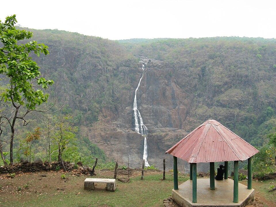
The district is famous above all for Similipal National Park, the core of one of India's oldest tiger reserves, which covers roughly a quarter of the district. It is also known for the unmasked Mayurbhanj Chhau, the chlorite-stone temple at Khiching, sabai grass craft and the GI-tagged Similipal Kai Chutney.
People of Mayurbhanj district

Census 2011 counted 25,19,738 people in 5,86,253 households in Mayurbhanj district. 7.7% lived in towns, and the literacy rate (age 7 and over) was 63.2%. The census recognised 5 towns in the district.

Population
25,19,738
12,56,213 male · 12,63,525 female
Households
5,86,253
about 4.3 people each
Literacy (age 7+)
63.2%
men 73.8% · women 52.7%
Females per 1,000 males
1,006
Girls per 1,000 boys (0–6)
960
People per km²
242
  • Rural23,26,842 (92.3%)
  • Urban1,92,896 (7.7%)
Scheduled Castes
1,84,682 (7.3%)
Scheduled Tribes
14,79,576 (58.7%)

What the 12,23,534 workers did

  • Cultivators1,71,380 (14.0%)
  • Agricultural labourers1,45,285 (11.9%)
  • Household industry35,730 (2.9%)
  • Other work1,95,995 (16.0%)
  • Marginal workers6,75,144 (55.2%)

Marginal workers worked less than six months of the year.

Source: Census of India 2011, Primary Census Abstract (district, sub-district and town level). Figures are from 2011, the most recent census with published district, town and village figures.

Facilities in the villages of Mayurbhanj

How many of the 3,751 inhabited villages of this district had each facility within the village itself, from the Census 2011 Village Directory. Together the 3,950 villages cover 7,233 km², 54% of it sown with crops and 14% forest.

Education

  • Primary school3,020 of 3,751
  • Middle school1,298 of 3,751
  • Secondary school550 of 3,751
  • Senior secondary school93 of 3,751
  • Degree college50 of 3,751

Health

  • Primary health centre12 of 3,751
  • Health sub-centre576 of 3,751
  • Anganwadi centre3,128 of 3,751

Water & power

  • Treated tap water0 of 3,751
  • Hand pump3,526 of 3,751
  • Electricity for homes2,740 of 3,751

Roads & transport

  • All-weather road2,916 of 3,751
  • Public bus292 of 3,751
  • Mobile phone coverage3,545 of 3,751

Services

  • Post office or sub post office789 of 3,751
  • Commercial bank0 of 3,751
  • Ration (PDS) shop1,314 of 3,751
  • Weekly haat461 of 3,751
Primary schools
4,034
Middle schools
1,895
Secondary schools
1,006
Degree colleges
52
Primary health centres
28
Health sub-centres
576

Main crops named by villages: Paddy (3,203), Vegetables (865), Maize (380), Ground Nuts (94), Sabai Grass (93), Maze (91), Black Gram (70), Wheat (69). Handicrafts: Leaf Plates (281), Grass Mats (139), Bamboo Products (17), Sal Leaf Plate, Khali Stiching (10), Mats (7), Sabai Rope (6), Khali Leaf Plate (5), Ornaments (2).

Source: Census of India 2011, District Census Handbook: Village and Town Directory (Odisha). The facilities were recorded for the 2011 census (reference year 2009 for most items); many places have changed since. Facilities in towns are not included.

Towns of Mayurbhanj

4 statutory towns (municipal corporation, municipality, notified area council or industrial township) and 1 census town — places the census counted as urban but which are governed by gram panchayats.

TownTypePopulationLiteracyWards
BaripadaMunicipality1,09,74388.5%31
RairangpurNotified Area Council25,51686.5%27
KaranjiaNotified Area Council22,86583.4%15
UdalaNotified Area Council13,15287.8%12
JashipurCensus town5,10174.5%–

Population of the town itself; for towns with outgrowths, the town page also gives the figure including them. Ward counts are the census wards of 2011.

Census sub-districts: town and country

Sub-districtPopulationRuralUrbanLiteracy
Tiring1,00,5171,00,517060.6%
Bahalda53,23153,231066.8%
Jamda48,81148,811059.2%
Rairangpur Town50,79815,86934,92978.6%
Gorumahisani47,65347,653053.7%
Jharpokharia99,79499,794063.7%
Bisoi73,89973,899060.7%
Rairangpur81,72281,722062.2%
Badampahar63,89063,890057.0%
Jashipur1,21,0301,15,9295,10157.5%
Raruan78,20978,209064.6%
Ghagarbeda28,90028,900062.4%
Karanjia1,14,38391,51822,86565.2%
Thakurmunda57,89057,890055.0%
Baripada Sadar87,09187,091057.4%
Baripada Town5,1495,149067.4%
Koliana82,81082,810062.9%
Bangiriposi1,04,9021,04,902058.5%
Chandua63,39063,390061.1%
Suliapada86,35586,355066.0%
Muruda77,33777,337064.9%
Rasagobindapur96,52696,526066.2%
Baisinga1,22,0361,22,036065.5%
Betanati89,66689,666065.7%
Barsahi1,32,5801,32,580063.9%
Khunta1,23,6161,23,616062.4%
Udala1,10,10496,95213,15264.2%
Kaptipada76,42776,427067.8%
Sharata77,36977,369042.0%
Mahuldiha46,80446,804047.5%
Baripada (M)1,16,84901,16,84987.3%

Odisha's census sub-districts are police-station areas, not revenue tahasils.

History

According to the district administration, the Bhanja dynasty ruled the region from about the 9th century CE. The early kingdom was known as Khijjinga Mandala, after its capital Khijjinga Kotta, the present-day Khiching. At its height it took in Mayurbhanj, Kendujhar and parts of present-day Jharkhand and West Bengal. Family tradition linked the rulers to the peafowl (mayura), which is often given as the origin of the name.

The capital later moved to Haripur, and around 1800 to Baripada. The region faced an invasion by the Delhi Sultan Firuz Shah Tughlaq in 1361. It later came under Mughal rule, then under the Marathas in the mid-18th century, and in 1803 it became a feudatory state under the British.

Mayurbhanj was regarded as one of the more progressive princely states. Maharaja Sriram Chandra Bhanj Deo (reigned 1882–1912) built roads and schools, constituted the Baripada Municipality in 1905, and promoted a narrow-gauge railway: the first section of the Mayurbhanj State Railway, from Rupsa to Baripada, opened on 20 January 1905. He presided over the first session of the Utkal Sammilani in 1903, a milestone in the movement for a separate Odisha (see Utkal Divas).

After Independence, Maharaja Pratap Chandra Bhanj Deo signed the instrument of merger on 17 October 1948, and Mayurbhanj merged with Odisha on 1 January 1949.

Places to visit

Similipal National Park

Similipal's sal forests, grasslands and waterfalls are the district's main draw. Barehipani and Joranda are among the highest waterfalls in Odisha, and visitors enter through the Pithabata gate near Baripada or the Kaliani gate near Jashipur. The park closes during the monsoon; check the official reserve website for dates. Details are in our Similipal travel guide.

Khiching and the Kichakeswari Temple

Khiching, in the Panchpir sub-division about 130 km from Baripada, was the early capital of the Bhanjas. Its Kichakeswari temple, dedicated to the family deity of the dynasty, is old, though sources differ on its date (the summaries on Wikipedia give the 8th century and about 920 CE), and was rebuilt in 1934 under Maharaja Pratap Chandra Bhanj Deo using chlorite stone. A museum founded at Khiching in 1922 displays sculpture from the area.

Devkund

Devkund (Debakunda) is a waterfall and pool on the edge of Similipal, about 25 km from Udala and 65 km from Baripada. A temple of Goddess Ambika stands above the lowest fall. It was built by Rajkumar Prafulla Chandra Bhanj Deo, who, according to local accounts, found a natural rock form of the goddess there.

Baripada

Baripada's Haribaldev temple, the town's Jagannath shrine, was built in 1575 CE of laterite and is about 84.5 ft tall, according to the district administration. During the Baripada Rath Yatra, held a day after Puri's, only women pull the chariot of Devi Subhadra. Wikipedia dates this custom to 1975. Baripada is also the main centre of Chhau performance.

Bhimkund

Bhimkund is a sacred pool in the Baitarani river near Booring village in Thakurmunda block, about 40 km from Karanjia, according to the district administration.

Haripurgarh

Haripur, which became the Bhanja capital after Khiching, is the site of the Rasika Raya temple at Haripurgarh, listed among the district's historic temples.

How to reach

  • By air: The district administration puts Baripada about 207 km from Biju Patnaik International Airport, Bhubaneswar, and about 195 km from Kolkata airport.
  • By rail: Baripada station is on the line from Rupsa to Bangriposi, which links with the Howrah–Chennai main line. Trains run to Balasore and Bhubaneswar. Badampahar station is about 18 km from Jashipur, on the northern side of Similipal.
  • By road: Baripada is about 255 km from Bhubaneswar and about 60 km from Balasore by road. NH-18 runs from Balasore through Baripada towards Jharkhand, and NH-49 crosses the district.

For more ideas, see how to reach Odisha and the map of Odisha districts.

Culture and festivals

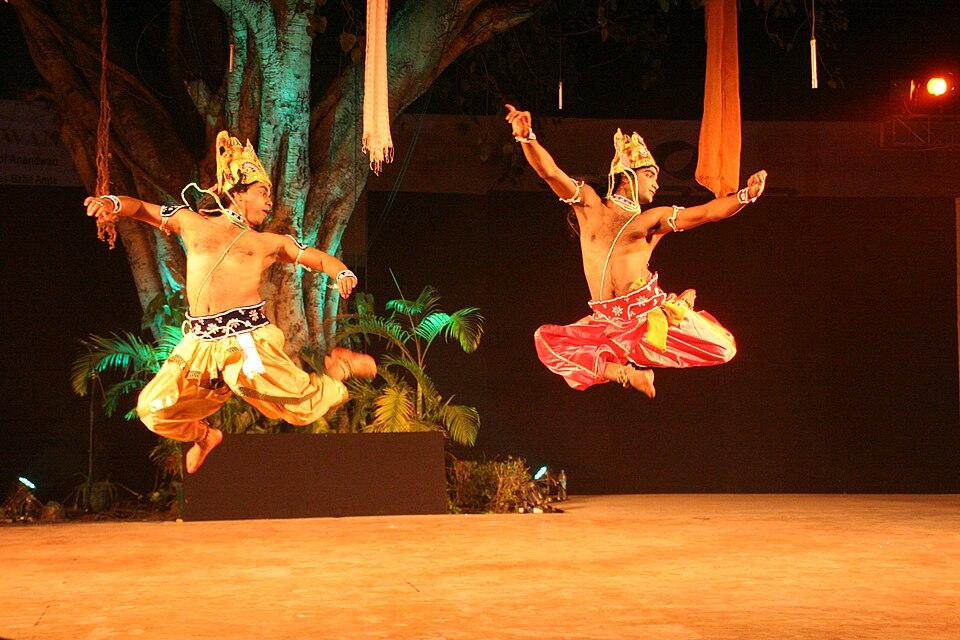
Mayurbhanj Chhau is the district's signature art. UNESCO inscribed Chhau dance, covering the Mayurbhanj, Seraikella and Purulia styles, on its intangible heritage list in 2010. Unlike the other two styles, Mayurbhanj Chhau is danced without masks. The main season is Chaitra Parba in spring, when troupes perform in Baripada. See Chhau dance.

The district administration names Makar Parba and Karama Parba as the two major festivals, and the Baripada Rath Yatra as the main religious festival. Jhumar is a folk song and dance tradition performed at weddings and festivals.

Mayurbhanj is home to many tribal communities. The largest are the Santal, Ho and Bhumij, and the Kharia and Mankirdia live in and around Similipal. Pandit Raghunath Murmu, born near Rairangpur, created the Ol Chiki script for Santali in 1925.

The main craft is sabai grass craft: rural women roll and weave the tough sabai grass into baskets, mats and decorative pieces.

Food

  • Similipal Kai Chutney: a chutney made with red weaver ants, registered as a Geographical Indication for Mayurbhanj in 2024. See GI tags of Odisha.
  • Mudhi mansa: puffed rice served with mutton curry, which Odisha Tourism associates with Mayurbhanj. See famous foods of Odisha.

Everyday Odia fare such as pakhala bhata and dalma is common across the district.

Geography and climate

Mayurbhanj sits on the north-eastern edge of the Odisha plateau. It borders Jhargram district of West Bengal, and East Singhbhum, Seraikela Kharsawan and West Singhbhum districts of Jharkhand, to the north and east. Within Odisha it borders Balasore to the south-east and Kendujhar to the west.

The Similipal hills rise in the centre of the district. Its highest point, Khairiburu, is about 1,178 m high, and nearby Meghasani reaches about 1,158 m. These hills feed several rivers, including the Budhabalanga, Baitarani, Subarnarekha, Salandi, Deo and Sone. Forest covered about 4,458 sq km, or roughly 43 percent of the district, according to figures summarised on Wikipedia.

The climate is subtropical, with hot summers and a heavy monsoon.

FeatureDetail
Area (2011 Census)10,418 sq km, largest in Odisha
Highest pointKhairiburu, about 1,178 m
Main protected areaSimilipal National Park and Tiger Reserve
Average annual rainfallAbout 1,648 mm
SummerTemperatures can exceed 45°C
WinterMinimum around 8°C

Similipal was declared a tiger reserve under Project Tiger in 1973, a biosphere reserve by India in 1994, and joined UNESCO's World Network of Biosphere Reserves in 2009. The wider reserve covers about 2,750 sq km. See our Similipal National Park travel guide for seasons and permits.

Economy

Most people work on the land. In the 2011 Census, about 19.5 percent of workers were cultivators and about 46.5 percent were agricultural labourers. Paddy is the main crop, with groundnut, maize, mung and mustard also grown.

The district has iron ore deposits at Gorumahisani, Badampahar and Sulaipat, served by railway branch lines towards Jamshedpur. Smaller deposits of china clay, kyanite and other minerals are also recorded. Forest produce and sabai grass are important sources of rural income. OrissaPOST reported in 2021 that sabai was grown on about 22,758 hectares of the district. Tourism centres on Similipal and Baripada.

Climate of Mayurbhanj

In Mayurbhanj district (at 21.94°N, 86.74°E), the hottest month is Apr (average highs of 38°C) and the coolest nights come in Jan (13°C). About 1420 mm of rain falls in a year, most of it in the monsoon; Aug is the wettest month.

JanFebMarAprMayJunJulAugSepOctNovDec
Average high (°C)263035383734313131302826
Average low (°C)131621252627262525221814
Rainfall (mm)14152329952063103372361211918
Rainy days2123716242519911

Averages for 1995–2024 at that point (43 m above sea level), from the Open-Meteo historical weather API (ERA5 reanalysis by ECMWF/Copernicus, CC BY 4.0) — modelled values on a ~25 km grid, not station readings from the India Meteorological Department. A rainy day has 2.5 mm or more.

Notable people

  • Maharaja Sriram Chandra Bhanj Deo (1870–1912), the ruler who modernised Mayurbhanj State.
  • Pandit Raghunath Murmu (1905–1982), born at Dandbose near Rairangpur, creator of the Ol Chiki script for Santali.
  • Droupadi Murmu, born in 1958 at Uparbeda village, MLA for Rairangpur from 2000 to 2009, Governor of Jharkhand, and the 15th President of India from 26 July 2022.
  • Jagadish Mohanty (born 1951 at Gorumahisani), an influential modern Odia fiction writer.

Blocks, sub-districts, panchayats & villages

Choose a block, sub-district or town to see its details and its gram panchayats and villages. Open any village for its own page.

Counts below: Local Government Directory, December 2022 snapshot (LGD villages, which can differ from the district administration's revenue-village count).

Blocks
26
Sub-districts
31
GPs
408
LGD villages
3,966

Community development block

Badasahi

Gram panchayats
30
Villages
224
LGD block code
3487
District
Mayurbhanj
Open full block page

Villages (…)

All blocks in Mayurbhanj

BlockGPsVillagesVillage pop.LiteracyST share
Badasahi302241,46,23264.3%50.7%
Bahalda1210787,65763.5%58.5%
Bangriposi192251,04,28758.6%69.8%
Baripada1110466,61757.4%75.0%
Betnoti242291,51,16866.6%41.3%
Bijatala1214360,28255.8%74.8%
Bisoi1315072,19260.9%69.2%
Gopabandhunagar1313577,05065.1%56.1%
Jamda107857,60960.3%73.5%
Joshipur2023096,23456.0%71.2%
Kaptipada261551,48,71754.5%66.6%
Karanjia1515691,51860.4%67.9%
Khunta1413273,42960.0%79.3%
Kuliana172451,04,75762.3%65.4%
Kusumi1411291,12959.6%64.4%
Morada201691,03,48564.7%43.7%
Rairangpur1213558,06961.5%59.2%
Raruan1210964,91962.9%55.2%
Rasgovindpur1617796,52666.2%54.6%
Samakhunta1413774,96158.7%67.5%
Saraskana171991,00,40963.6%57.7%
Sukruli109061,88564.1%61.2%
Suliapada161851,00,22066.2%41.1%
Thakurmunda181731,04,69451.7%74.9%
Tiring118057,62860.9%74.3%
Udala128775,16861.3%73.8%

GPs and villages: Local Government Directory (Dec 2022). Village population, literacy and Scheduled Tribe share: sum of the block's villages in Census of India 2011, Primary Census Abstract (village level).

All census sub-districts

Towns (urban local bodies)

Assembly constituencies in Mayurbhanj

Source: Local Government Directory (lgdirectory.gov.in), Government of India — data dump of December 2022 via github.com/planemad/india-local-government-directory. Sub-districts follow the Local Government Directory, which for Odisha uses the Census sub-districts (police-station areas) — these are not the same as revenue tahasils. Boundaries and names change over time; check the district administration for current status.

Frequently asked questions

Is Mayurbhanj the largest district of Odisha?

Yes. With an area of 10,418 sq km in the 2011 Census, Mayurbhanj is the largest of Odisha's 30 districts by area. It was the third most populous, with 2,519,738 people.

What is Mayurbhanj famous for?

Mayurbhanj is known for Similipal National Park and Tiger Reserve, the Mayurbhanj style of Chhau dance, the Kichakeswari temple at Khiching, the Baripada Rath Yatra and the GI-tagged Similipal Kai Chutney.
How far is Baripada from Bhubaneswar?

The district administration gives the road distance from Bhubaneswar to Baripada as about 255 km. Balasore, on the Howrah–Chennai main line, is about 60 km away.

When did Mayurbhanj join Odisha?

The ruler of Mayurbhanj State signed the instrument of merger on 17 October 1948, and Mayurbhanj merged with Odisha on 1 January 1949, becoming a district.

What is special about the Baripada Rath Yatra?

At Baripada only women pull the chariot of Devi Subhadra, a custom the district administration describes as unique. The festival is held a day after the Puri Rath Yatra.

Sources & references

  1. 1Mayurbhanj District: Census 2011 data — Census2011.co.in (compiled from Census of India 2011)
  2. 2History — District Administration, Mayurbhanj, Government of Odisha
  3. 3Culture & Heritage — District Administration, Mayurbhanj (NIC)
  4. 4How to Reach — District Administration, Mayurbhanj (NIC)
  5. 5Mayurbhanj district — Wikipedia
  6. 6Mayurbhanj State — Wikipedia
  7. 7Khiching — Wikipedia
  8. 8Simlipal National Park — Wikipedia

Last reviewed . How we check articles

Report an error