Skip to content

Sambalpur district

ସମ୍ବଲପୁର ଜିଲ୍ଲା

Sambalpur district in western Odisha: Samaleswari Temple, Hirakud Dam, Sambalpuri handloom, Sitala Sasthi and Veer Surendra Sai. History, places, how to reach.

Headquarters
Sambalpur
Population (2011)
1,041,099
Area
6,624 sq km
Villages
1,318
Literacy (2011)
76.2%
Towns (2011)
6

Sambalpur (ସମ୍ବଲପୁର) is a district in western Odisha whose headquarters, Sambalpur city, is the main urban and cultural centre of the region. Sambalpur district is known for the Samaleswari Temple, the Hirakud Dam on the Mahanadi, and the Sambalpuri bandha handloom tradition.

Sambalpur district lies in the Mahanadi basin in north-western Odisha. Its headquarters city takes its name from the goddess Samalei, or Samaleswari, who is regarded as the presiding deity of the region. In older times the area was also known as Hirakhanda, a name linked to the diamonds once traded here.

The district has three sub-divisions: Sambalpur, Kuchinda and Rairakhol. It covers 6,624 sq km according to the 2011 Census (some official sources give a slightly larger figure) and had a population of 1,041,099 in 2011. About 30 percent of the people lived in towns, mainly in the Sambalpur urban area, and Scheduled Tribes made up roughly a third of the population.

Sambalpur was once a far larger district. After Independence it also included what are now Bargarh, Jharsuguda and Deogarh. Bargarh was separated in 1993, and Jharsuguda and Deogarh followed in 1994, leaving the present district.

Today Sambalpur is a hub for education, administration and railways in western Odisha. It is home to Sambalpur University, Veer Surendra Sai University of Technology at Burla, VIMSAR medical college and IIM Sambalpur. Sambalpur is also the headquarters of the Sambalpur division of East Coast Railway.
People of Sambalpur district

Census 2011 counted 10,41,099 people in 2,49,597 households in Sambalpur district. 29.6% lived in towns, and the literacy rate (age 7 and over) was 76.2%. The census recognised 6 towns in the district.

Population
10,41,099
5,26,877 male · 5,14,222 female
Households
2,49,597
about 4.2 people each
Literacy (age 7+)
76.2%
men 84.4% · women 67.9%
Females per 1,000 males
976
Girls per 1,000 boys (0–6)
940
People per km²
156
  • Rural7,33,006 (70.4%)
  • Urban3,08,093 (29.6%)
Scheduled Castes
1,91,827 (18.4%)
Scheduled Tribes
3,55,261 (34.1%)

What the 5,05,840 workers did

  • Cultivators72,629 (14.4%)
  • Agricultural labourers73,078 (14.4%)
  • Household industry34,007 (6.7%)
  • Other work1,57,140 (31.1%)
  • Marginal workers1,68,986 (33.4%)

Marginal workers worked less than six months of the year.

Source: Census of India 2011, Primary Census Abstract (district, sub-district and town level). Figures are from 2011, the most recent census with published district, town and village figures.

Facilities in the villages of Sambalpur

How many of the 1,228 inhabited villages of this district had each facility within the village itself, from the Census 2011 Village Directory. Together the 1,312 villages cover 4,198 km², 31% of it sown with crops and 26% forest.

Education

  • Primary school1,046 of 1,228
  • Middle school559 of 1,228
  • Secondary school272 of 1,228
  • Senior secondary school61 of 1,228
  • Degree college41 of 1,228

Health

  • Primary health centre3 of 1,228
  • Health sub-centre154 of 1,228
  • Anganwadi centre950 of 1,228

Water & power

  • Treated tap water0 of 1,228
  • Hand pump1,228 of 1,228
  • Electricity for homes1,142 of 1,228

Roads & transport

  • All-weather road819 of 1,228
  • Public bus136 of 1,228
  • Mobile phone coverage1,135 of 1,228

Services

  • Post office or sub post office225 of 1,228
  • Commercial bank2 of 1,228
  • Ration (PDS) shop267 of 1,228
  • Weekly haat99 of 1,228
Primary schools
1,337
Middle schools
640
Secondary schools
368
Degree colleges
42
Primary health centres
10
Health sub-centres
154

Main crops named by villages: Paddy (1,065), Pulses (325), Vegetables (184), Harad (96), Spices (93), Wheat (81), Biri (62), Mustard (55). Handicrafts: Bidi (15), Khali (14), Furnitures (13), Broom Stick (13), Mats (13), Mat (12), Dana (12), Leaf Plates (11).

Source: Census of India 2011, District Census Handbook: Village and Town Directory (Odisha). The facilities were recorded for the 2011 census (reference year 2009 for most items); many places have changed since. Facilities in towns are not included.

Towns of Sambalpur

5 statutory towns (municipal corporation, municipality, notified area council or industrial township) and 1 census town — places the census counted as urban but which are governed by gram panchayats.

TownTypePopulationLiteracyWards
SambalpurMunicipality1,84,00085.5%31
BurlaNotified Area Council46,69885.7%16
HirakudNotified Area Council30,20784.0%17
KochindaNotified Area Council15,57681.9%11
RedhakholNotified Area Council15,37982.4%18
RengaliCensus town10,86779.0%–

Population of the town itself; for towns with outgrowths, the town page also gives the figure including them. Ward counts are the census wards of 2011.

Census sub-districts: town and country

Sub-districtPopulationRuralUrbanLiteracy
Govindpur59,14159,141069.9%
Mahulpalli76,63276,632069.7%
Kochinda81,66866,09215,57672.8%
Katarbaga29,87529,875073.5%
Thelkoloi26,91526,915075.8%
Rengali26,85915,99210,86777.8%
Sasan63,79063,790074.6%
Hirakud37,8877,68030,20779.9%
Burla85,81439,11646,69879.9%
Dhanupali7,7277,727079.0%
Ainthapali12,62712,627076.6%
Sadar46,66046,660075.7%
Jamankira59,25059,250069.9%
Kisinda20,46020,460072.6%
Jujomura57,27157,271071.3%
Dhama44,57944,579073.5%
Charamal29,52629,526075.8%
Rairakhol55,50240,12315,37977.1%
Naktideul29,55029,550073.4%
Sambalpur (M)1,89,36601,89,36685.4%

Odisha's census sub-districts are police-station areas, not revenue tahasils.

History

The Sambalpur region has a long recorded history. The Roman-era geographer Ptolemy, writing in the 2nd century CE, mentions a place called Sambalaka. It is usually identified with Sambalpur, which was known for exporting diamonds. In the early medieval period the area came under the Somavamsi kings (around the 9th century) and later the Eastern Gangas, before passing to the Gajapati kings.

The defining era began with the Chauhan rulers. A branch of the Chauhans first ruled the Patna kingdom (around present-day Balangir), and in the 16th century Balaram Dev founded a separate kingdom at Sambalpur. Odisha Tourism says Balaram Dev made Samaleswari the state's chief goddess in about 1542 CE, while other accounts date the founding of the kingdom to around 1570. The Chauhans ruled Sambalpur for nearly three centuries and built many Shiva temples.

The Marathas of Nagpur took Sambalpur in 1800. After the Anglo-Maratha wars it came under British control in 1817, and in 1849 the British annexed it under the doctrine of lapse after Raja Narayan Singh died without a male heir.

Resistance to British rule centred on Veer Surendra Sai (1809–1884), a Chauhan claimant to the throne. He took up arms in 1827, was imprisoned at Hazaribagh, was freed by rebels in 1857 and led a guerrilla campaign in the forests until he surrendered in 1862. Re-arrested in 1864, he died at Asirgarh fort in 1884 after spending about 37 years in British prisons.

Under British rule Sambalpur moved between provinces several times: to the Central Provinces in 1862, back to Bengal in 1905, then to Bihar and Orissa in 1912, and into the new Orissa province in 1936. On 1 January 1948 the princely state of Rairakhol acceded to India and became part of Sambalpur district, and the Bamra state around Deogarh was also absorbed. The Hirakud Dam was inaugurated by Prime Minister Jawaharlal Nehru on 13 January 1957. Read more in Sambalpur history.

Places to visit

Samaleswari Temple

The temple of Maa Samaleswari in Sambalpur city, on the bank of the Mahanadi, is the region's most important shrine. Odisha Tourism notes that its main priests trace their descent to the Chauhan family. Major festivals here include Nuakhai, Mahavisuba Sankranti and the nine-day Durga Puja.

Hirakud Dam

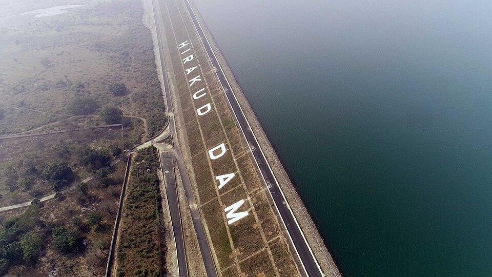
Hirakud is a large earthen dam across the Mahanadi near Sambalpur. Its main dam is about 4.8 km long, and with its dykes the whole structure runs to about 25.8 km. It is often described as the longest earthen dam in the world. Gandhi Minar and Jawahar Minar, towers at either end, give wide views over the reservoir, which has been a Ramsar wetland since 2021. See the Hirakud Dam travel guide.

Huma Leaning Temple

At Huma, about 23 km south of Sambalpur on the Mahanadi, stands the leaning temple of Vimaleswara (Bimaleswar), a form of Shiva. The main temple and the smaller shrines around it tilt at different angles, and Odisha Tourism suggests the lean may have been deliberate. Odisha Tourism dates the temple to around the mid-16th century; other accounts credit Chauhan kings of the 17th century with rebuilding it. Visitors feed the fish in the temple pond, and a fair is held at Shivaratri.

Ghanteswari Temple and Chiplima

The Ghanteswari temple near Chiplima is known for the many bells hung there by devotees. According to Wikipedia, Chiplima also has a natural waterfall about 24 m high.

Budharaja Temple

A Shiva temple on a hillock within Sambalpur city, one of several Shiva shrines built in the Chauhan period.

Ushakothi and Khalasuni sanctuaries

These forested sanctuaries in the north of the district shelter elephants, leopards and many forest birds. Visitor facilities are limited, so check with the forest department before going.

How to reach

  • Air: Veer Surendra Sai Airport, Jharsuguda, is the nearest airport, about 60 km by road. Biju Patnaik International Airport in Bhubaneswar is roughly 300 to 325 km away.
  • Rail: Sambalpur is a railway junction and the headquarters of a division of East Coast Railway, with trains to Bhubaneswar, Puri, Rourkela, Raipur and other cities.
  • Road: National Highways 53 and 55 pass through Sambalpur, and the Biju Expressway links it with Rourkela and Bargarh. The road journey from Bhubaneswar is roughly 290 to 325 km, depending on the route. Odisha Tourism gives 287 km to nearby Huma.

For other districts, see the districts of Odisha or the map.

Temples (8)

  • Gandhi Temple, Bhatara · ଗାନ୍ଧୀ ମନ୍ଦିର, ଭତରା
  • Ghanteswari Temple · ଘଣ୍ଟେଶ୍ଵରୀ ମନ୍ଦିର
  • Kosalesvara Temple
  • Leaning Temple of Huma · ବିମଳେଶ୍ଵର ଦେଉଳ
  • Maa Samleswari Temple
  • Samalesvari Temple
  • Samaleswari Temple · ସମଲେଶ୍ଵରୀ ମନ୍ଦିର
  • Vimalesvara Temple

Photos and map links in the temple directory. Today's tithi, sunrise and Rahu Kala here.

Protected monuments (1)

Monuments of National Importance protected by the Archaeological Survey of India. All of Odisha.

Railway stations

17 stations and 0 halts inside the district, as mapped on OpenStreetMap; some on new lines may not yet have regular trains.

Culture and festivals

Sambalpur is the centre of a distinct western Odisha culture, with its own language variety, music and dance. Many people speak Sambalpuri (also called Kosli) at home, alongside standard Odia. The district is also home to communities such as the Kisan, Munda and Oraon.

  • Nuakhai is the most important festival of western Odisha. Families eat the first rice of the new harvest together, and the goddess Samaleswari receives the first offering.
  • Sitala Sasthi celebrates the wedding of Shiva and Parvati in Jyeshtha (May–June). In Sambalpur, local families act as the bride's parents, and Shiva's wedding procession passes through the city.
  • Sambalpuri dance: folk forms such as Dalkhai and Rasarkeli are performed to the dhol, nisan and mahuri at festivals.
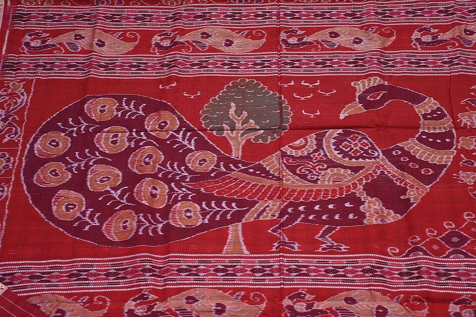
  • Handloom: the Sambalpuri saree, woven with the bandha (tie-dye) technique, is a registered Geographical Indication as "Sambalpuri Bandha Saree and Fabrics". Weaving is spread across the western districts. See Odisha's GI tags.
  • Crafts: a central government district profile lists bamboo work, dhokra metal casting and lac bangles among the district's craft clusters.

Food

Sambalpur shares the food culture of western Odisha. Chaula bara, a crisp fried snack of rice batter, is sold in Sambalpur and nearby towns, often with green chillies and tamarind soup. Other regional favourites include dishes made with kardi (tender bamboo shoot) and hendua (dried bamboo shoot), and lethaa, a sour vegetable soup also called ambil. Festival sweets include rasbaraa and tikhri. Fish from the Mahanadi and the Hirakud reservoir is common in local cooking.

Geography and climate

Sambalpur district borders Sundargarh to the north, Deogarh to the east, Angul and Subarnapur to the south, and Bargarh and Jharsuguda to the west. The Mahanadi, Odisha's longest river, enters from the north-west, where it is held back by the Hirakud Dam. Smaller streams in the district include the Maltijor, Harrad, Kulsara, Bheden and Phuljharan.

The land falls into three broad zones: hilly country around Bamra and Kuchinda in the north, plateau ridges near Rairakhol in the south-east, and the more open valleys and plains of the Sambalpur sub-division. Large parts of the north and south-east are forested. Sources differ widely on the exact forest cover, depending on how forest is measured.

The district has two wildlife sanctuaries of its own. Ushakothi (Badrama) Wildlife Sanctuary, notified in 1962, covers about 304 sq km. Khalasuni Wildlife Sanctuary, set up in 1982, covers about 116 sq km and is part of an important elephant corridor. Debrigarh Wildlife Sanctuary lies on the far shore of the Hirakud reservoir, in neighbouring Bargarh district.

Climate featureTypical value
Hottest monthMay, with peaks of about 47 °C
Coolest monthDecember, with lows of around 11–12 °C
Annual rainfallAbout 1,530 mm, mostly June to October
Rainy daysAbout 66 per year

Climate figures as summarised by Wikipedia's Geography of Sambalpur article.

Economy

Agriculture and forestry are the traditional base of Sambalpur's economy. Water from the Hirakud project supports paddy farming in the plains, and the district has many rice mills. Kendu leaf, used to roll bidis, is an important forest product and is often called the "green gold" of Odisha.

Industry has grown around power, aluminium and steel. A government district profile names Hindalco, sponge iron and steel units, and Mahanadi Coalfields among the large establishments. Minerals found in the district include bauxite, coal, dolomite, graphite and quartz. Handloom weaving, government services, education and the railway division are also major employers. In 2006 the central government listed Sambalpur among India's 250 most backward districts, making it eligible for the Backward Regions Grant Fund.

Climate of Sambalpur

In Sambalpur district (at 21.47°N, 83.98°E), the hottest month is May (average highs of 40°C) and the coolest nights come in Jan (15°C). About 1490 mm of rain falls in a year, most of it in the monsoon; Aug is the wettest month.

JanFebMarAprMayJunJulAugSepOctNovDec
Average high (°C)273135394035303031312927
Average low (°C)151721252827252525231915
Rainfall (mm)1714141430230406412257741213
Rainy days2111214242418711

Averages for 1995–2024 at that point (155 m above sea level), from the Open-Meteo historical weather API (ERA5 reanalysis by ECMWF/Copernicus, CC BY 4.0) — modelled values on a ~25 km grid, not station readings from the India Meteorological Department. A rainy day has 2.5 mm or more.

Notable people

  • Veer Surendra Sai (1809–1884): freedom fighter, born at Khinda, about 40 km north of Sambalpur; Jharsuguda's airport is named after him.
  • Bhima Bhoi: the 19th-century poet-saint of Mahima Dharma. Some accounts place his birth in the Rairakhol area, though sources differ.
  • Shriyanka Sadangi (born 1995 in Sambalpur): rifle shooter, gold medallist at the 2019 South Asian Games.

Blocks, sub-districts, panchayats & villages

Choose a block, sub-district or town to see its details and its gram panchayats and villages. Open any village for its own page.

Counts below: Local Government Directory, December 2022 snapshot (LGD villages, which can differ from the district administration's revenue-village count).

Blocks
9
Sub-districts
20
GPs
138
LGD villages
1,318

Community development block

Bamra

Gram panchayats
17
Villages
138
LGD block code
3558
District
Sambalpur
Open full block page

Villages (…)

All blocks in Sambalpur

BlockGPsVillagesVillage pop.LiteracyST share
Bamra1713897,76669.7%62.2%
Dhankauda98383,40072.0%32.8%
Jamankira2124894,78670.2%56.5%
Jujomura181401,04,57473.4%45.9%
Kuchinda1713371,31670.2%51.4%
Maneswar129078,85875.9%32.7%
Naktideul1420463,82673.2%27.5%
Rairakhol1421455,83375.8%24.7%
Rengali166881,37774.7%42.3%

GPs and villages: Local Government Directory (Dec 2022). Village population, literacy and Scheduled Tribe share: sum of the block's villages in Census of India 2011, Primary Census Abstract (village level).

All census sub-districts

Towns (urban local bodies)

Assembly constituencies in Sambalpur

Source: Local Government Directory (lgdirectory.gov.in), Government of India — data dump of December 2022 via github.com/planemad/india-local-government-directory. Sub-districts follow the Local Government Directory, which for Odisha uses the Census sub-districts (police-station areas) — these are not the same as revenue tahasils. Boundaries and names change over time; check the district administration for current status.

Frequently asked questions

What is Sambalpur famous for?

Sambalpur is known for the Samaleswari Temple, the Hirakud Dam on the Mahanadi, Sambalpuri bandha (ikat) handloom, the Sitala Sasthi festival and its link with the freedom fighter Veer Surendra Sai.

How far is Hirakud Dam from Sambalpur?

Hirakud Dam is roughly 10 to 15 km from Sambalpur city; sources give slightly different figures depending on the point measured.

Which is the nearest airport to Sambalpur?

Veer Surendra Sai Airport at Jharsuguda, about 60 km away by road. Biju Patnaik International Airport in Bhubaneswar is roughly 300 to 325 km away.

When were Bargarh, Jharsuguda and Deogarh separated from Sambalpur?

Bargarh became a separate district in 1993, and Jharsuguda and Deogarh (Debagarh) were separated in 1994.

Sources & references

  1. 1Sambalpur District: Census 2011 data — Census2011.co.in (compiled from Census of India 2011)
  2. 2Samaleswari Temple — Odisha Tourism, Government of Odisha
  3. 3Huma Temple — Odisha Tourism, Government of Odisha
  4. 4Brief Industrial Profile of Sambalpur District — MSME-Development Institute, Ministry of MSME, Government of India
  5. 5Sambalpur District at a Glance — District Administration, Sambalpur, Government of Odisha
  6. 6Sambalpur district — Wikipedia
  7. 7Surendra Sai — Wikipedia

Last reviewed . How we check articles

Report an error