Skip to content

Subarnapur district

ସୁବର୍ଣ୍ଣପୁର ଜିଲ୍ଲା

Subarnapur (Sonepur) district sits where the Tel meets the Mahanadi. Known as a temple town and for Bomkai and Sonepuri handloom. History, places, how to reach.

Headquarters
Sonepur
Population (2011)
610,183
Area
2,337 sq km
Villages
963
Literacy (2011)
74.4%
Towns (2011)
4

Subarnapur (ସୁବର୍ଣ୍ଣପୁର), better known by the name of its headquarters, Sonepur, is a district in western Odisha at the meeting point of the Mahanadi and Tel rivers. Subarnapur district is famous for its many temples, which have earned Sonepur the popular title "Second Varanasi", and for its Bomkai and Sonepuri handloom saris.

The name Subarnapur means "city of gold". Wikipedia notes that in the 8th century the area was known as Swarnapur (Suvarnapura), and that it was also called Paschima Lanka (Western Lanka), a name echoed in the cult of its guardian goddess, Lankeswari.

The district was created on 1 April 1993, when it was separated from Balangir district. Before that, the area had been the princely state of Sonepur, which merged with Odisha on 1 January 1948. The district headquarters is Sonepur town.

Subarnapur covers 2,337 sq km and had 610,183 people at the 2011 Census. It is overwhelmingly rural: only about 8 percent of the people lived in towns. Its blocks include Sonepur, Binika, Tarbha, Dunguripali, Birmaharajpur and Ullunda. Sambalpuri (Kosli) is the most common mother tongue, spoken by about 60 percent of people at the 2011 Census, followed by Odia. Subarnapur has two sub-divisions, Sonepur and Birmaharajpur.

People of Subarnapur district

Census 2011 counted 6,10,183 people in 1,51,136 households in Subarnapur district. 8.2% lived in towns, and the literacy rate (age 7 and over) was 74.4%. The census recognised 4 towns in the district.

Population
6,10,183
3,11,312 male · 2,98,871 female
Households
1,51,136
about 4.0 people each
Literacy (age 7+)
74.4%
men 84.4% · women 64.0%
Females per 1,000 males
960
Girls per 1,000 boys (0–6)
952
People per km²
261
  • Rural5,60,242 (91.8%)
  • Urban49,941 (8.2%)
Scheduled Castes
1,56,219 (25.6%)
Scheduled Tribes
57,192 (9.4%)

What the 2,86,661 workers did

  • Cultivators62,626 (21.8%)
  • Agricultural labourers53,939 (18.8%)
  • Household industry12,928 (4.5%)
  • Other work40,725 (14.2%)
  • Marginal workers1,16,443 (40.6%)

Marginal workers worked less than six months of the year.

Source: Census of India 2011, Primary Census Abstract (district, sub-district and town level). Figures are from 2011, the most recent census with published district, town and village figures.

Facilities in the villages of Subarnapur

How many of the 856 inhabited villages of this district had each facility within the village itself, from the Census 2011 Village Directory. Together the 962 villages cover 1,944 km², 58% of it sown with crops and 11% forest.

Education

  • Primary school746 of 856
  • Middle school330 of 856
  • Secondary school117 of 856
  • Senior secondary school21 of 856
  • Degree college18 of 856

Health

  • Primary health centre1 of 856
  • Health sub-centre76 of 856
  • Anganwadi centre697 of 856

Water & power

  • Treated tap water0 of 856
  • Hand pump786 of 856
  • Electricity for homes726 of 856

Roads & transport

  • All-weather road585 of 856
  • Public bus68 of 856
  • Mobile phone coverage786 of 856

Services

  • Post office or sub post office110 of 856
  • Commercial bank0 of 856
  • Ration (PDS) shop151 of 856
  • Weekly haat69 of 856
Primary schools
879
Middle schools
359
Secondary schools
149
Degree colleges
18
Primary health centres
3
Health sub-centres
76

Main crops named by villages: Paddy (687), Pulses (162), Mung (81), Vegetable (64), Til (28), Onion (19), Mustard (17), Spices (15). Handicrafts: Bamboo Basket (1), Terracota (1).

Source: Census of India 2011, District Census Handbook: Village and Town Directory (Odisha). The facilities were recorded for the 2011 census (reference year 2009 for most items); many places have changed since. Facilities in towns are not included.

Towns of Subarnapur

3 statutory towns (municipal corporation, municipality, notified area council or industrial township) and 1 census town — places the census counted as urban but which are governed by gram panchayats.

TownTypePopulationLiteracyWards
SonapurMunicipality20,77088.5%15
BinikaNotified Area Council15,76575.8%12
TarbhaNotified Area Council8,33482.7%12
SubalayaCensus town5,07283.2%–

Population of the town itself; for towns with outgrowths, the town page also gives the figure including them. Ward counts are the census wards of 2011.

Census sub-districts: town and country

Sub-districtPopulationRuralUrbanLiteracy
Dunguripali1,15,7131,15,713072.9%
Rampur43,21543,215077.0%
Binika96,63480,86915,76575.2%
Ulunda41,25841,258072.2%
Biramaharajpur1,00,4021,00,402076.7%
Subalaya43,56438,4925,07277.7%
Sonapur60,45539,68520,77078.8%
Tarbha1,08,9421,00,6088,33469.2%

Odisha's census sub-districts are police-station areas, not revenue tahasils.

History

Finds of punch-marked coins point to settlement in the Sonepur area between about the 3rd century BCE and the 1st century CE. According to the Wikipedia history of Sonepur, the Somavamsi king Janmejaya I (about 850–885 CE) took the region from the Bhanjas and founded the Suvarnapura kingdom. In the 10th and 11th centuries Suvarnapura was one of the two capitals of the Somavamsi dynasty.

Later rulers included the Telugu Chodas, from about 1070 CE, and the Kalachuris, from about 1113 CE. The Eastern Ganga king Anangabhima Deva III conquered the area in the early 13th century.

The Chauhan Sonepur State was founded in the 17th century, when a prince of the Patna (Balangir) Chauhan line took the area from the Bhanja rulers of Boudh and gave it to Madan Gopal. Sources differ on the date, giving either 1640 or 1650. The state signed an agreement with the East India Company in 1803 and came under British protection after 1817. Sonepur covered about 2,347 sq km in 1901, close to the present district's area. It was a nine-gun salute state.

The ruler of Sonepur acceded to India on 1 January 1948, and the state became part of Balangir district. It was separated again as Subarnapur district in 1993.

Places to visit

Lankeswari Temple

The shrine of the goddess Lankeswari, also called Nikumbhila, stands on a rock in the bed of the Mahanadi at Sonepur. Lankeswari was the principal deity of the old Paschima Lanka, and she is worshipped by the Kaibarta community of Sonepur and by people across the district. The shrine can be seen from the road between Ulunda and Birmaharajpur.

Subarnameru Temple

A Shiva temple on the bank of the Tel in Sonepur town. Its main festivals are Shivaratri and Kartik Purnima.

The Mahanadi–Tel confluence

The meeting of the two rivers at Sonepur is the town's sacred centre. Many of its temples cluster along the riverbanks, which gives the town its "Second Varanasi" reputation.

Patali Srikhetra, Kotsamlai

Patali Srikhetra lies at the foot of Trikut hill at Kotsamlai, in the Birmaharajpur sub-division. According to tradition recorded in the Madala Panji, the temple chronicle of Puri, the images of Jagannath, Balabhadra and Subhadra were hidden in the caves of Trikut to protect them from invaders, and were later recovered by the Somavamsi king Yayati Keshari. This gives the site its name, Patali Srikhetra ("underground Srikhetra"). The site is also important to Shakta and Buddhist traditions.

Khaliapali

Khaliapali is the site of the ashram of the poet-saint Bhima Bhoi, set up around 1877 according to the Odia Virtual Academy. It is a place of pilgrimage for followers of Mahima Dharma. Bhima Bhoi, who was raised in a Kondh (Kandha) Adivasi family, composed devotional works such as Stuti Chintamani and many bhajans that are still sung in western Odisha. Popular tradition remembers him as blind, though the Odia Virtual Academy says he was not born blind.

How to reach

  • Air: the nearest airport is Veer Surendra Sai Airport, Jharsuguda, about 142 km from Sonepur according to Wikipedia. Biju Patnaik International Airport, Bhubaneswar, also serves the district by road.
  • Rail: Sonepur is on the Khurda Road–Balangir railway project, which is being opened in stages. The established railheads nearby are Balangir and Sambalpur. Check current train services before travel.
  • Road: National Highways 57 and 126A and State Highways 15 and 41 connect Sonepur with Sambalpur, Balangir, Boudh and Bhubaneswar.

See also neighbouring Balangir, Boudh, Bargarh and Sambalpur, or browse all districts of Odisha.

Railway stations

3 stations and 0 halts inside the district, as mapped on OpenStreetMap; some on new lines may not yet have regular trains.

Culture and festivals

Subarnapur is one of Odisha's leading handloom districts.

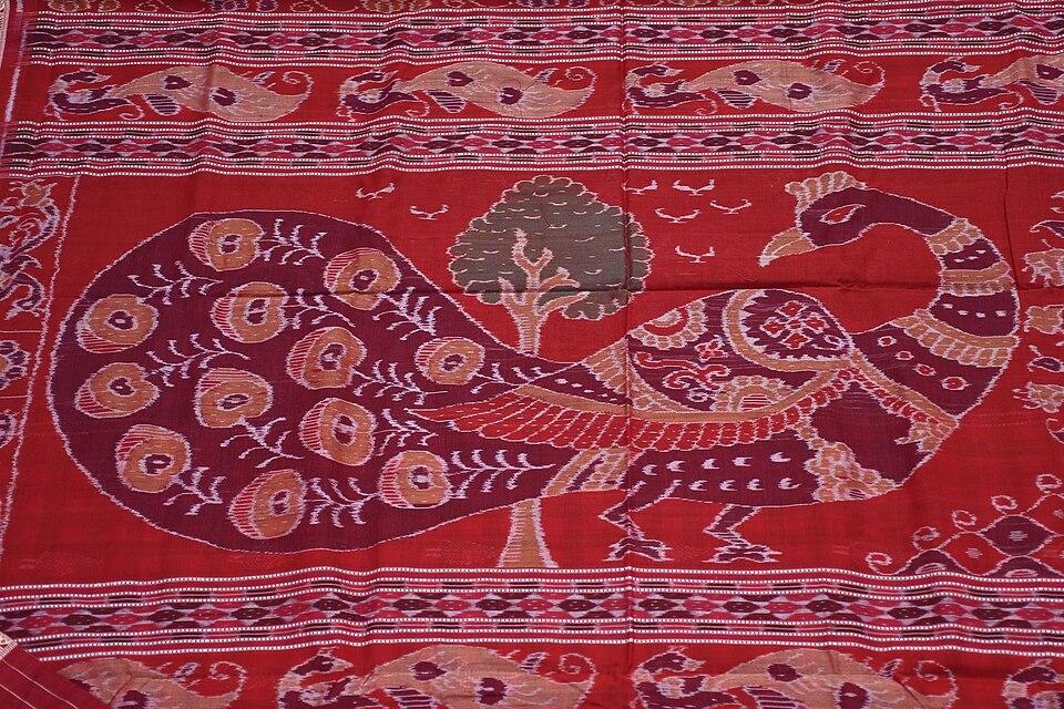
  • Bomkai saree: the Bomkai saree, registered as a Geographical Indication ("Bomkai Saree and Fabrics"), is today woven mainly by the Bhulia weavers of Subarnapur, which is why it is often called Sonepuri Bomkai. Its thick extra-weft borders and pallus often combine with ikat. According to accounts in Odisha's handloom histories, the Bomkai style reached Sonepur from Ganjam during the rule of a king of Patna state. Weavers add extra threads to raise motifs such as fish, temple spires and lotuses, and borders in a contrasting colour are woven with a three-shuttle method known locally as muhajorha.
  • Sambalpuri bandha: Subarnapur is also a major centre for the GI-registered Sambalpuri saree. See Odisha's GI tags.
  • Festivals: Nuakhai is the main family festival. Shivaratri and Kartik Purnima are celebrated at the riverside temples.
  • Folk performance: Sambalpuri dance forms such as Dalkhai are part of festival life.
  • Language: Subarnapur is a heartland of Sambalpuri (Kosli), which is written in the Odia script. About one in seven of the language's 2.63 million native speakers counted in 2011 live in the district. Speakers campaign for its inclusion in the Eighth Schedule of the Constitution.
  • Mahima Dharma: through Bhima Bhoi's ashram at Khaliapali, the district has a lasting link with the Mahima Dharma movement and its devotional songs.

Food

Subarnapur's food is that of western Odisha. Rice is the staple, and fresh fish from the Mahanadi and Tel is common in local cooking. Chaula bara, crisp rice-batter fritters served with tamarind soup, is a popular snack in Sonepur and across the region. Bamboo-shoot dishes (kardi and hendua) and festival sweets such as rasbaraa and tikhri are also part of the local table.

Geography and climate

Subarnapur lies in the middle Mahanadi valley. The Mahanadi flows through the district, and the Tel, one of its largest tributaries, joins it at Sonepur town. The confluence is the reason Sonepur grew up as a sacred site. River plains along the Mahanadi and Tel make up much of the farmland.

Climate featureTypical value
SummerHot; average summer highs given as about 45 °C
WinterMild
Annual rainfallAbout 1,440 mm, mostly June to September

Climate figures as summarised by Wikipedia's Subarnapur district article.

Economy

Agriculture is the main occupation. Paddy is the main crop of the river valleys. Handloom weaving is the district's best-known industry: households of Bhulia and other weaving communities produce Bomkai and bandha saris, which are also sold through Odisha's state handloom cooperatives. Wikipedia notes that Sonepur is also known for its river prawns.

Climate of Subarnapur

In Subarnapur district (at 20.83°N, 83.92°E), the hottest month is May (average highs of 41°C) and the coolest nights come in Jan (16°C). About 1370 mm of rain falls in a year, most of it in the monsoon; Aug is the wettest month.

JanFebMarAprMayJunJulAugSepOctNovDec
Average high (°C)283237404136313031313028
Average low (°C)161923272928262525232017
Rainfall (mm)1412111231192372373249751415
Rainy days1111213222217711

Averages for 1995–2024 at that point (104 m above sea level), from the Open-Meteo historical weather API (ERA5 reanalysis by ECMWF/Copernicus, CC BY 4.0) — modelled values on a ~25 km grid, not station readings from the India Meteorological Department. A rainy day has 2.5 mm or more.

Notable people

  • Bhima Bhoi (c. 1850–1895): poet-saint of Mahima Dharma who set up his ashram at Khaliapali in the former Sonepur state. Sources differ on his birthplace.
  • Chaturbhuj Meher (born in Sonepur): master ikat weaver, awarded the Padma Shri in 2005, who trained thousands of weavers.
  • Kailash Chandra Meher (born in Sonepur): painter known for tussar pattachitra and contemporary art, awarded the Padma Shri in 2013.

Blocks, sub-districts, panchayats & villages

Choose a block, sub-district or town to see its details and its gram panchayats and villages. Open any village for its own page.

Counts below: Local Government Directory, December 2022 snapshot (LGD villages, which can differ from the district administration's revenue-village count).

Blocks
6
Sub-districts
8
GPs
109
LGD villages
963

Community development block

Binika

Gram panchayats
16
Villages
99
LGD block code
3567
District
Subarnapur
Open full block page

Villages (…)

All blocks in Subarnapur

BlockGPsVillagesVillage pop.LiteracyST share
Binika169991,11874.5%13.3%
Birmaharajpur1518289,60277.5%5.4%
Dunguripali261121,22,07975.4%12.8%
Sonepur1415982,14671.3%9.1%
Tarbha2118484,74767.9%8.1%
Ullunda1722790,55073.9%9.2%

GPs and villages: Local Government Directory (Dec 2022). Village population, literacy and Scheduled Tribe share: sum of the block's villages in Census of India 2011, Primary Census Abstract (village level).

All census sub-districts

Towns (urban local bodies)

Assembly constituencies in Subarnapur

Source: Local Government Directory (lgdirectory.gov.in), Government of India — data dump of December 2022 via github.com/planemad/india-local-government-directory. Sub-districts follow the Local Government Directory, which for Odisha uses the Census sub-districts (police-station areas) — these are not the same as revenue tahasils. Boundaries and names change over time; check the district administration for current status.

Frequently asked questions

Why is Sonepur called the Second Varanasi?

Sonepur has a large cluster of temples on the banks of the Mahanadi and Tel rivers, much like Varanasi on the Ganga, and is popularly called the 'Second Varanasi'. Wikipedia describes the town as having more than 100 temples.

Are Subarnapur and Sonepur the same?

Yes. Subarnapur is the official name of the district, and its headquarters town is Sonepur (also spelt Sonpur or Subarnapur).

What is the Bomkai saree's link with Sonepur?

The Bomkai saree takes its name from Bomkai village in Ganjam, but today it is woven mainly by the Bhulia weavers of Subarnapur district, so it is often called Sonepuri Bomkai. 'Bomkai Saree and Fabrics' is a registered Geographical Indication.

When was Subarnapur district formed?

Subarnapur district was created on 1 April 1993, when it was separated from Balangir district.

Sources & references

  1. 1Subarnapur District: Census 2011 data — Census2011.co.in (compiled from Census of India 2011)
  2. 2Subarnapur District at a Glance — District Administration, Subarnapur, Government of Odisha
  3. 3Subarnapur district — Wikipedia
  4. 4History of Sonepur, Odisha — Wikipedia
  5. 5Sonepur State — Wikipedia
  6. 6Lankeswari Temple — Wikipedia
  7. 7Patali Srikhetra — Wikipedia
  8. 8Bhima Bhoi — Odia Virtual Academy, Government of Odisha

Last reviewed . How we check articles

Report an error